Start your project with reliable, scan-accurate documentation you can trust.


STATS
Years in As-Built Documentation
U.S. Markets Served
±2mm
Verified Dimensional Accuracy
Buildings Documented
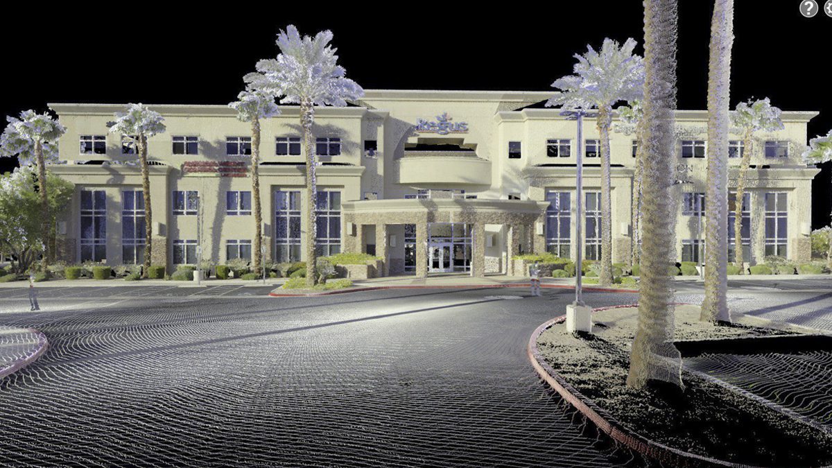
Point Cloud Services — Precision Documentation for Commercial Construction
LiDAR Precise Plans delivers professional point cloud services across seven Southwest markets: Las Vegas, Phoenix, Los Angeles, San Francisco, Denver, Salt Lake City, and Austin. With 27 years of commercial architecture experience, we help architects, contractors, and facility managers prevent costly construction conflicts through millimeter-accurate 3D laser scanning data.
Our point cloud services capture, process, register, and deliver spatial datasets that serve as the authoritative record of existing building conditions — replacing guesswork with verified measurements that protect budgets, timelines, and project quality.
Why Point Cloud Services Matter: A single avoided construction conflict — relocating one run of mechanical ductwork after installation — typically costs more than the entire scanning investment. Point cloud data eliminates dimensional uncertainty before work begins, not after. That is the core value of professional point cloud services.
What Are Point Cloud Services?
Point cloud services capture, process, register, and deliver three-dimensional datasets composed of millions of precisely measured spatial points. Each point carries X, Y, and Z coordinates that define exact locations in space, creating a comprehensive digital representation of a building or site as it physically exists — not as designed or assumed.
For commercial construction and facility management, point cloud data serves as the foundation for as-built drawings, BIM models, MEP coordination, clash detection, and renovation planning. Rather than relying on outdated drawings or manual field measurements, project teams work from verified spatial intelligence that reflects true existing conditions.
- 🏛️ As-Built Documentation
- 🔧 MEP System Coordination
- 📋 Clash Detection & Prevention
- 📊 Renovation Planning
- 🏢 Tenant Improvement Planning
- 🖥️ BIM Workflow support
- 📍 Facility Condition Baselines
- 🛖 Historic Preservation Documentation
- 💰 Due Diligence & Property Assessment
- ✅ QA/QC Verification & Progress Tracking
Point Cloud Processing Services
Raw scan data captured in the field requires expert processing before it becomes actionable project intelligence. Our point cloud processing services transform field-captured datasets into clean, organized, and deliverable formats — applying rigorous quality control at every step.
Noise Filtering and Cleanup
Every scan environment introduces erroneous data points: reflective surfaces scatter laser returns, moving objects create phantom geometry, and environmental interference adds noise throughout the dataset. Our noise filtering and cleanup process removes these erroneous points systematically, preserving valid building geometry while eliminating outliers that would corrupt downstream modeling or drawing production.
Data Normalization
Raw point cloud data arrives in scanner-native coordinate systems with varying density distributions. Data normalization re-scales, re-orients, and standardizes the dataset to client-specified coordinate systems and point density requirements — ensuring consistent data quality across all delivered files regardless of field conditions during capture.
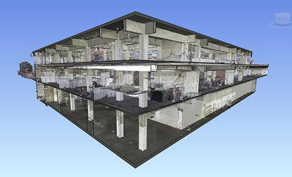
Point Cloud Segmentation
Complex commercial buildings require organized data to be navigable. Point cloud segmentation divides the dataset by building level, area, system, or user-defined criteria — enabling project teams to isolate the fourth floor mechanical room, the lobby envelope, or the rooftop HVAC without wading through complete building datasets. Segmented data accelerates downstream workflows in Revit, Navisworks, and AutoCAD.
QA/QC Process
Every delivered dataset passes our internal quality assurance and quality control process before delivery. QA/QC verification confirms registration accuracy across all scan positions, validates that coverage is complete with no unintended gaps, checks noise filtering effectiveness, and verifies that delivered formats open cleanly in target software environments. We document QA/QC findings and provide accuracy reports on request.
Point Cloud Registration Services
Capturing a commercial building requires dozens to hundreds of individual scan positions. Point cloud registration is the process of aligning these individual scans into a single unified coordinate system — the critical step that determines whether the final dataset achieves specified accuracy tolerances or introduces systematic errors that propagate through all downstream work.
Coordinate System Alignment
We establish project coordinate systems using survey-grade control targets placed throughout the scan environment. These targets serve as known reference points that tie scanner positions to a defined coordinate framework — whether a local building datum, state plane coordinates, or a client-specified system. Coordinate system alignment ensures that the final point cloud integrates seamlessly with site surveys, existing CAD files, and BIM environments.
Target-Based Registration
Target-based registration uses precisely placed survey control targets — typically spherical or checkerboard flat targets — as reference geometry for aligning individual scan positions. This approach delivers the highest achievable registration accuracy because target centers can be detected with sub-millimeter precision in scan data. We use target-based registration as the primary methodology for commercial construction projects where accuracy tolerances are tightest.
Cloud-to-Cloud Registration
In environments where target placement is impractical — occupied spaces, complex geometry, or areas with limited access — cloud-to-cloud registration aligns overlapping point cloud segments by matching geometric features present in adjacent scans. Modern cloud-to-cloud algorithms achieve registration accuracy approaching target-based methods in environments with sufficient geometric detail. We use cloud-to-cloud registration as a supplementary method or for specific conditions where target-based approaches are constrained.
Scan Alignment and Accuracy Tolerances
Professional scan alignment achieves 2-6mm registration accuracy for typical commercial building applications. Final accuracy depends on scanner equipment quality, target placement density, scan overlap percentage, and environmental stability during capture. We specify accuracy tolerances for each project during consultation and document achieved accuracy in deliverable reports — giving clients verified performance data rather than nominal equipment specifications.
How long does point cloud registration take?
Registration processing for a typical 50,000 SF commercial building requires 1-3 business days after field work is complete. Larger projects with 100+ scan positions may require 3-5 days. Rush registration processing is available for time-sensitive projects. We include registration completion in overall project schedules quoted during consultation.
Point Cloud Deliverables
Our point cloud deliverables are configured during project kickoff based on your software environment, workflow requirements, and downstream applications. We deliver registered, cleaned, and verified datasets in the formats your team works with — not generic exports that require additional processing.
Deliverable File Formats
We support all major point cloud file formats used in commercial construction and facility management workflows:
.E57
.RCP / .RCS
.LAS / .LAZ
.PTS / .PTX
.XYZ
- .E57: Industry-standard point cloud exchange format with full metadata support. Accepted by Revit, AutoCAD, Navisworks, Leica Cyclone, and virtually all professional point cloud processing applications.
- .RCP and .RCS: Autodesk ReCap project and scan formats optimized for AutoCAD, Revit, and Civil 3D. RCP files index multiple RCS scans into a single managed project, streamlining workflow for large building datasets.
- .LAS and .LAZ: LiDAR data exchange formats carrying XYZ coordinates, intensity values, RGB color, and classification attributes. LAZ is the compressed variant — identical data at 10-15% of uncompressed file size. Standard for infrastructure and large-area scanning projects.
- .PTS and .PTX: ASCII text formats providing universal software compatibility. PTX includes per-scan transformation matrices enabling individual scan extraction. Suitable for custom applications and legacy software environments.
- .XYZ: Simple three-column coordinate format for import into custom applications, programming environments, and analysis tools requiring unformatted spatial data.
Documentation Workflow
Our documentation workflow begins with a project kickoff consultation confirming scope, accuracy requirements, format preferences, and delivery schedule. Following field capture, we process and register the dataset, complete QA/QC verification, prepare deliverable files, and provide project documentation including scan coverage maps, registration reports, and format-specific integration notes. Final delivery occurs via secure file transfer or cloud platform access depending on project size and client preference.
Point Cloud Data Processing
The gap between raw field data and project-ready deliverables is where expertise determines outcome quality. Our point cloud data processing services apply commercial-grade processing software and methodical workflows developed over hundreds of commercial scanning projects.
Point Cloud Conversion Services
Many projects require data in formats different from native scan output. Our point cloud conversion services translate datasets between formats while preserving coordinate accuracy, color information, and metadata attributes. Common conversion workflows include scanner-native format to E57 for software-neutral archiving, E57 to RCP/RCS for Autodesk platform integration, and LAS to RCP for projects bridging survey and architectural workflows.
Format conversion is performed with attention to coordinate system preservation — ensuring that converted files maintain the same spatial alignment as source data. We document conversion parameters and verify output accuracy before delivery.
Registered Point Cloud Delivery
The registered point cloud is the primary deliverable for most projects — a unified, multi-scan dataset aligned to a defined coordinate system, cleaned of noise, and verified for accuracy. We deliver registered point clouds in client-specified formats with supporting documentation that enables your team to immediately integrate data into existing software environments without additional processing.
Do we deliver registered point clouds? Yes — registered, cleaned, QA/QC-verified datasets are our standard deliverable for all scanning projects. Raw unregistered scans are available on request for clients with internal processing capability who prefer to manage alignment workflows.
Point Cloud to CAD
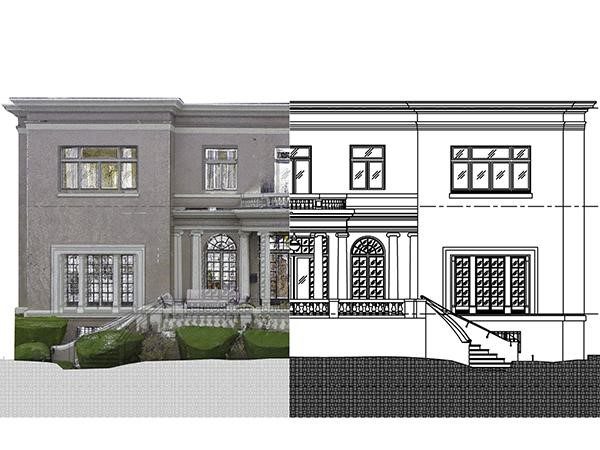
Registered point cloud datasets can be used to produce 2D CAD documentation when required. For projects that require full scan-to-CAD conversion — including floor plans, elevations, sections, and drafting to firm layer standards — see our dedicated Scan-to-CAD Services page.
Our point cloud team focuses on delivering clean, registered, QA/QC-verified datasets that serve as the foundation for downstream CAD production — whether handled by your internal team or by our dedicated drafting specialists.
Point Cloud to BIM
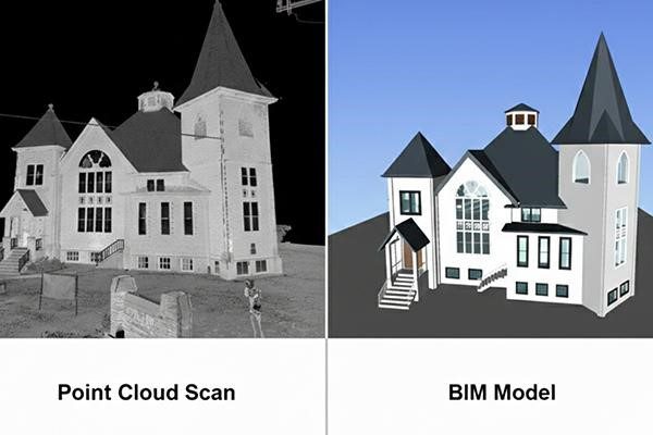
Registered point cloud datasets can be used to develop BIM models when required. For projects requiring full Scan-to-BIM modeling — including LOD specifications, Revit deliverables, and coordination-ready models — visit our dedicated Scan-to-BIM Services page.
Point Cloud Modeling Services
Beyond standard CAD and BIM deliverables, our point cloud modeling services support specialized downstream applications — from point cloud visualization for client presentations to custom geometry extraction for engineering analysis, facade modeling for restoration work, and parametric element modeling for facility management integration.
Point cloud visualization services convert registered datasets into navigable 3D environments accessible via web browser, desktop viewer, or cloud platform. This visualization capability enables project stakeholders to review building conditions remotely, extract measurements without software licenses, and collaborate across distributed teams without site visits.
Point Cloud Services Pricing
Point cloud services pricing depends on project scope, building complexity, geographic location, required deliverables, and turnaround timeline. We provide fixed-fee proposals for defined scopes after a brief consultation — not open-ended time-and-materials arrangements that create budget uncertainty.
What is included in point cloud processing?
Our point cloud processing services include: (1) noise filtering and cleanup to remove erroneous data points; (2) scan registration aligning all positions to a unified coordinate system; (3) data normalization and segmentation by building level and area; (4) format conversion to client-specified deliverable formats; (5) QA/QC verification with accuracy documentation; and (6) file delivery via secure transfer. Color optimization for RGB data is included where color information was captured.
- Free consultation and project scoping
- Fixed-fee proposals within 24-48 hours
- 5-10 business day standard turnaround
- Rush services for urgent timelines
- Multi-market coverage eliminates travel premiums
- Deliverables configured to your software workflow
- QA/QC reports included with all projects
- No open-ended billing surprises
Frequently Asked Questions — Point Cloud Services
A: Professional point cloud registration achieves 2-6mm accuracy for typical commercial building applications using survey-grade LiDAR equipment. Accuracy depends on scanner quality, target placement density, scan overlap percentage, and environmental conditions. We document achieved registration accuracy in QA/QC reports delivered with every project — giving clients verified performance data rather than nominal equipment specifications.
A: We deliver point cloud data in all major industry formats: .E57, .RCP and .RCS (Autodesk ReCap), .LAS and .LAZ, .PTS and .PTX, and .XYZ. Format selection is confirmed during project kickoff based on your software environment. Multiple format delivery is available at no additional cost for projects requiring data in more than one format.
A: Yes — registered, noise-filtered, QA/QC-verified point cloud datasets are our standard deliverable for all scanning projects. Every delivery includes documentation of registration methodology, achieved accuracy, scan coverage, and format integration notes. Raw unregistered scans can be provided on request for clients with internal processing workflows.
A: Registration processing for a typical 50,000 SF commercial building requires 1-3 business days after field work completion. Large projects exceeding 200,000 SF or 100+ scan positions may require 3-5 days. Rush processing is available for time-critical schedules. Overall project timelines — from field mobilization to final delivery — typically run 5-10 business days for standard commercial buildings, with detailed schedules provided in project proposals.
A: Point cloud processing includes noise filtering and cleanup, scan registration and coordinate system alignment, data normalization, segmentation by building level and area, format conversion to specified deliverable formats, RGB color optimization, QA/QC verification with accuracy documentation, and file delivery. All processing steps are performed using commercial-grade software with methodical QA review before delivery.
A: Registered point cloud data can be used for downstream CAD documentation when required. For detailed information about our full Scan-to-CAD production services and drafting standards, please visit our dedicated Scan-to-CAD Services page.
A: Registered point cloud datasets can serve as the foundation for BIM development. For complete Scan-to-BIM workflows, LOD specifications, and Revit deliverables, visit our Scan-to-BIM Services page.
A: Point cloud services pricing is based on building square footage, scan complexity, required deliverables, geographic location, and timeline. We provide fixed-fee proposals within 24-48 hours of consultation — typical commercial projects are priced per building rather than per scan position or hourly. Contact us for a free project consultation and detailed proposal specific to your scope.
Point Cloud Services Across Seven Southwest Markets
Our regional presence enables rapid mobilization — typically 24-48 hours across our coverage area — and eliminates travel premiums common with national scanning providers. We understand the specific building types, local construction practices, and client environments in each market we serve.
Las Vegas, NV
Headquarters • Gaming & Hospitality
Phoenix, AZ
Resort & Commercial Office
Los Angeles, CA
High-Rise & Flagship Retail
San Francisco, CA
Tech Sector & Historic Buildings
Denver, CO
Commercial Real Estate & Hospitality
Salt Lake City, UT
Retail & Facility Management
Austin, TX
Technology Sector Growth & Commercial Development
Get a Point Cloud Services Quote
We provide free project consultations and deliver detailed fixed-fee proposals within 24-48 hours. Tell us your building type, approximate square footage, location, and required deliverables — we’ll provide a specific scope and price.
Call Direct
888-543-2711
Mon–Fri, 8am–5pm PST
info@lidarpreciseplans.com
Response within 4 business hours
Request Quote
Online Quote Form
Proposal within 24–48 hours