Start your project with reliable, scan-accurate documentation you can trust.

Expert Verdict
This guide breaks down the real technical differences between professional LiDAR scanners (Leica & FARO) and Matterport’s photogrammetry platform — so you can choose the right technology before committing to documentation that may not meet construction-grade standards.
A technical deep dive into three competing reality-capture technologies — and why the scanner you choose directly determines the quality, accuracy, and legal defensibility of your as-built documentation.
Professional LiDAR
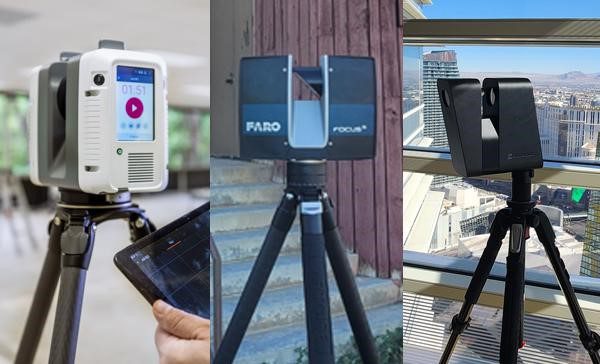
Leica RTC360
±2mm
- Range: 200m
- Scan speed: 2M pts/sec
- Exterior capable: Yes
- Point cloud export: E57, RCP, PTS
Best for: as-builts, BIM, tenant improvement, permit drawings
Construction-grade. Full point cloud. Best for as-builts, BIM, tenant improvement.
Professional LiDAR
FARO Focus
±2-3mm
- Range: 250m
- Scan speed: 976K pts/sec
- Exterior capable: Yes
- Point cloud export: FLS, E57, LAS
Best for: large facilities, industrial plants, campus environments
Construction-grade. Best for large facilities, industrial, and campus environments.
Consumer / Marketing
Matterport Pro3
±20mm
- Range: 100m max
- Scan speed: ~20 sec/pos
- Exterior capable: No
- Point cloud export: E57 (limited)
Best for: real estate marketing, virtual tours under 10,000 sq ft only
Real estate tours only. Not suitable for permit drawings, BIM, or construction use.
Bottom line: For commercial as-built documentation, BIM deliverables, renovation surveys, and any project where measurement accuracy matters — Leica and FARO professional LiDAR scanners are the industry standard. Matterport is a photogrammetry-based virtual tour platform best suited for real estate marketing and small interior walkthroughs. This guide explains exactly why — with specs, accuracy data, data-ownership implications, and project-type guidance.
Choosing the wrong scanner can make your as-built documentation unbuildable. Here’s exactly how Leica, FARO, and Matterport compare — on accuracy, deliverables, and data ownership.
This guide breaks down the real technical differences between professional LiDAR scanners (Leica & FARO) and Matterport’s photogrammetry platform — so you can choose the right technology before committing to documentation that may not meet construction-grade standards.
A technical deep dive into three competing reality-capture technologies — and why the scanner you choose directly determines the quality, accuracy, and legal defensibility of your as-built documentation.
Expert Verdict
Bottom line: For commercial as-built documentation, BIM deliverables, renovation surveys, and any project where measurement accuracy matters — Leica and FARO professional LiDAR scanners are the industry standard. Matterport is a photogrammetry-based virtual tour platform best suited for real estate marketing and small interior walkthroughs. This guide explains exactly why — with specs, accuracy data, data-ownership implications, and project-type guidance.Leica vs FARO vs Matterport — Quick Comparison
| Feature | Leica | FARO | Matterport |
|---|---|---|---|
| Accuracy | ±2mm | ±2-3mm | ±20mm |
| Raw Point Cloud | Yes | Yes | No |
| BIM Ready | Yes | Yes | No |
| Subscription Required | No | No | Yes |
Understanding What Each Technology Actually Does
Before comparing specifications, it’s important to understand that these three technologies occupy fundamentally different categories. Leica and FARO manufacture professional terrestrial LiDAR scanners designed for surveyors, architects, and construction professionals. Matterport is a consumer technology company that makes 3D camera hardware and a cloud-based virtual tour platform — it is not a professional scanning instrument.
Leica Geosystems — RTC360 · BLK360 G2 · P-Series
Category: Professional LiDAR | Grade: ✓ Professional
Swiss-engineered terrestrial LiDAR scanners with submillimeter range accuracy, designed for construction, architecture, engineering, and surveying. Industry gold standard for speed, portability, and workflow integration with Leica Cyclone and Autodesk software. Point clouds export to E57, LGS, RCP, and PTS formats — directly compatible with AutoCAD, Revit, and NavisWorks. No subscription required to access your data.
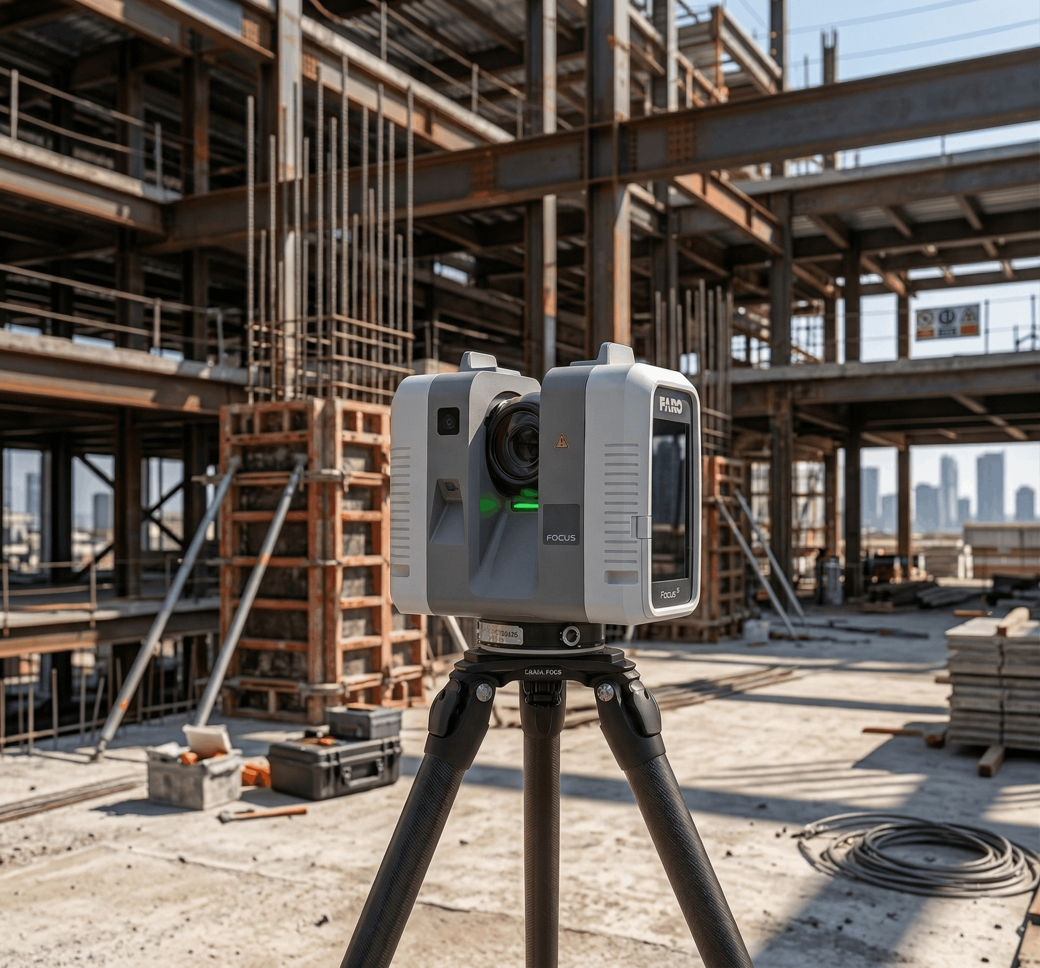
FARO Technologies — Focus Premium · Focus S · Focus M
Category: Professional LiDAR | Grade: ✓ Professional
High-precision phase-based and time-of-flight LiDAR scanners built for large-format industrial, architectural, and civil engineering applications. FARO’s SCENE software delivers powerful registration and data management workflows for complex multi-story buildings. Known for exceptional range (up to 350m) and accuracy in outdoor and large industrial environments. Full data ownership — files are delivered locally with no platform dependency.
Matterport — Pro3 · Pro2 · Compatible iPad Cameras
Category: Consumer / Prosumer | Grade: ⚠ Consumer / Marketing Tool
Photogrammetry-based 3D media platform designed for real estate marketing, retail visualization, and property management walkthroughs. Captures images and stitches them into an interactive 3D dollhouse model — primarily a visual experience tool, not a measurement instrument. Requires ongoing monthly subscription to access and host your captures. Data ownership and usage rights are governed by Matterport’s platform terms.
Scan Accuracy: The Number That Defines Your Project
For architects drawing construction documents, contractors bidding tenant improvement work, or engineers modeling existing conditions, scan accuracy is not an abstract spec — it directly determines whether your drawings are buildable and your coordination is conflict-free. The following figures represent 3D positional accuracy at typical indoor working ranges.
±2mm
3D Point Accuracy
Leica RTC360 | @ 10m range
±2-3mm
3D Point Accuracy
FARO Focus Premium | @ 10m range
±20mm
Floor Plan Accuracy
Matterport Pro3 | Typical interior
To put this in perspective: a 20mm tolerance across a 10,000 sq ft floor plate can accumulate dimensional errors large enough to shift a door rough opening by 40–60mm — causing fit-out conflicts that cost thousands to resolve in the field. Professional LiDAR operating at ±1–2mm eliminates that risk at the source.
Leica vs FARO vs Matterport: Head-to-Head Comparison
The following table evaluates all three platforms across the technical, operational, and commercial dimensions that matter most for commercial real estate, construction, and architecture projects.
| Parameter | Leica Geosystems | FARO Technologies | Matterport |
|---|---|---|---|
| TECHNICAL SPECIFICATIONS | |||
| Scan Technology | Time-of-flight LiDAR | Phase-based LiDAR | Photogrammetry |
| Point Accuracy | ±2mm | ±2-3mm | ±20mm |
| Effective Range | Up to 130m | Up to 350m | Up to 20m effective |
| Scan Speed | 2M pts/sec | 976K pts/sec | ~1–3 min/position |
| Exterior Scanning | ✓ Full exterior capable | ✓ Full exterior capable | ✗ Interior only |
| Point Cloud Export | E57, LGS, RCP, PTS, XYZ | FLS, E57, PTS, XYZ, LAS | No raw point cloud export |
| DELIVERABLE CAPABILITY | |||
| As-Built Floor Plans | ✓ Construction-grade | ✓ Construction-grade | ✗ Schematic only, ±1–3% |
| Revit BIM Models | ✓ Full LOD 200–400 | ✓ Full LOD 200–400 | ✗ Not supported |
| MEP Documentation | ✓ Full MEP capable | ✓ Full MEP capable | ✗ Not supported |
| 3D Virtual Walkthrough | ~ Via Cyclone Publisher | ~ Via FARO WebShare | ✓ Native feature |
| Permit-Grade Drawings | ✓ Yes | ✓ Yes | ✗ No |
| DATA OWNERSHIP & PRIVACY | |||
| Client Owns Raw Data | ✓ Delivered directly | ✓ Delivered directly | ✗ Stored on Matterport cloud |
| Monthly Subscription | ✓ None — data yours forever | ✓ None — data yours forever | ✗ Required to access captures |
| Data Persistence | Permanent, no expiration | Permanent, no expiration | Expires if subscription lapses |
| Platform Data Rights | Client retains full rights | Client retains full rights | Matterport TOS grants usage rights |
| PROJECT SCALE & TYPE | |||
| Max Project Size | ✓ Unlimited scale | ✓ Unlimited — ideal large facilities | Best under 10,000 sq ft |
| Multi-Story Buildings | ✓ Floor-to-floor alignment | ✓ Floor-to-floor alignment | ~ Limited vertical integration |
| Best Use Case | As-builts, BIM, renovation | Large facility, industrial, campus | Real estate marketing, tours |
Which Scanner Is Right for Your Project?
The correct technology choice depends entirely on what you need to do with the data. Here’s how to match platform to purpose for common commercial project types.
1. Tenant Improvement & Renovation → Leica RTC360
Architects need precise as-built floor plans to design tenant improvements without costly RFIs. Construction documents derived from Matterport’s ±20mm floor plans will generate field conflicts. Leica and FARO deliver ±2mm accuracy that flows directly into Revit or AutoCAD without re-measuring.
2. Large Commercial Facilities → FARO Focus Premium
Multi-story office towers, distribution centers, and campus environments require scan data that registers accurately across hundreds of scan positions covering millions of square feet. FARO’s long-range scanning and robust SCENE registration software handles these at scale.
3. Hospitality & Retail Chain Documentation → Leica RTC360
Major retail brands need standardized store documentation across markets for rollout prototypes and renovation management. LiDAR delivers consistent, measurable floor plans and reflected ceiling plans at every location — no measurement variance between sites.
4. Real Estate Marketing & Virtual Tours → Matterport (limited)
If your only requirement is an interactive 3D walkthrough for a property listing — not measurable drawings — Matterport can serve this limited purpose adequately for residential and small commercial interiors under 10,000 sq ft. It is not suitable for any project requiring accurate floor plans, BIM, or construction coordination.
5. MEP & Facilities Management → FARO Focus + Revit MEP
Documenting mechanical, electrical, and plumbing systems in an existing building for a major renovation requires capturing pipes, ducts, and conduits at scan accuracy that resolves into BIM. Matterport cannot produce MEP documentation at any level of development.
6. Permitting & Construction Documentation → Leica RTC360 + CAD
Building departments and contractors require drawings that represent actual existing conditions with sufficient accuracy to support permitting and bidding. Matterport’s schematic floor plans do not meet this standard. LiDAR-derived CAD drawings produced by licensed professionals are the standard of care.
Detailed Technical Specifications
The following specifications summarize the key hardware characteristics of the flagship instruments in each lineup.
| Leica RTC360 | FARO Focus Premium | Matterport Pro3 | |||
|---|---|---|---|---|---|
| Technology | Time-of-flight LiDAR | Technology | Phase-based LiDAR | Technology | Photogrammetry |
| Accuracy | ±2mm | Accuracy | ±2-3mm | Accuracy | ±20mm typical |
| Range | 130m | Range | 350m | Range | 20m effective |
| Scan Speed | 2M pts/sec | Scan Speed | 976K pts/sec | Scan Speed | ~20 sec/position |
| Field of View | 360° × 300° | Field of View | 360° × 300° | Field of View | 360° panoramic |
| Weight | 5.35 kg | Weight | 4.2 kg | Weight | 0.88 kg |
| Software | Cyclone / Recap | Software | FARO SCENE | Software | Matterport Cloud |
| Class | Professional | Class | Professional | Class | Consumer / Prosumer |
Questions About Leica, FARO & Matterport
Both Leica and FARO produce professional-grade LiDAR scanners with sub-2mm accuracy — they are peers in the professional scanning market. Key differences come down to range, scan speed, and software ecosystem. Leica's RTC360 is the fastest scanner in its class (2M pts/sec) and integrates seamlessly into Autodesk workflows via Recap. FARO's Focus Premium offers longer range (350m vs 130m) and is often preferred for large industrial plants, outdoor facades, and campus environments. For typical commercial interior as-built projects, either platform delivers equivalent accuracy and output quality.
No. Matterport generates schematic floor plans using its automated AI-based floorplan tool, but these plans carry tolerances of ±1–3% — which translates to 100–300mm of error on a 10-meter dimension. Construction documents, permit drawings, and as-built surveys require positional accuracy in the ±3–5mm range at minimum. Drawings produced from Matterport captures are not suitable for contractor bidding, permit applications, BIM coordination, or any use where dimension accuracy is critical.
LiDAR Precise Plans uses both Leica and FARO professional LiDAR scanners, selecting the instrument best suited to each project's scale, geometry, and deliverable requirements. For fast-turnaround commercial interior projects — retail stores, office suites, restaurant fit-outs — the Leica RTC360 provides the fastest field acquisition. For large multi-story facilities, industrial plants, or exterior façade documentation, FARO Focus equipment is deployed. All projects are delivered with full accuracy specifications, and raw point cloud files are included in project deliverables at no additional charge.
A point cloud is a dense three-dimensional dataset of millions of measured points captured by a LiDAR scanner — essentially a digital twin of the physical environment at sub-millimeter resolution. Every wall surface, ceiling, column, beam, window opening, and mechanical system is represented by millions of precisely located XYZ coordinates. Drafters and BIM modelers trace these points to produce accurate as-built floor plans, sections, elevations, and Revit models. Matterport does not produce a true point cloud; it generates a mesh model that is not suitable for professional documentation workflows.
Professional LiDAR scanning from a qualified provider typically costs $0.05–$0.20 per square foot depending on project size, complexity, and deliverable scope — with as-built floor plan packages starting around $800–$1,500 for smaller commercial spaces. The crucial distinction is deliverable value: a Matterport capture cannot produce permit-ready drawings or BIM models. Once you account for the full cost of achieving a construction-grade deliverable, professional LiDAR scanning is almost always more cost-effective.
LiDAR Precise Plans provides professional 3D laser scanning and as-built documentation services across seven Southwest markets:
Las Vegas, NV
Phoenix, AZ
Los Angeles, CA
San Francisco, CA
Denver, CO
Salt Lake City, UT
Austin, TX
Our team includes AIA Allied Members with 27+ years of commercial architecture experience, and we have completed projects for Nike, Apple, Coca-Cola, REI, Urban Outfitters, and ARIA Resort Las Vegas.
Continue Your Research
The following pages provide deeper information on related topics covered in this comparison guide:
- What Is 3D Laser Scanning? — lidarpreciseplans.com/resources/what-is-3d-laser-scanning
- What Is a 3D Point Cloud? — lidarpreciseplans.com/resources/what-is-a-point-cloud
- As-Built Drawings Guide — lidarpreciseplans.com/resources/as-built-drawings-guide
- BIM Modeling LOD Guide — lidarpreciseplans.com/resources/bim-modeling-lod-guide
- Laser Scanning vs. Photogrammetry — lidarpreciseplans.com/resources/laser-scanning-vs-photogrammetry
- Scan Accuracy vs. Site Accuracy — lidarpreciseplans.com/resources/scan-accuracy-guide
Stop Guessing. Start Building From Verified Existing Conditions.
LiDAR Precise Plans delivers Leica and FARO-based scanning with full point cloud deliverables, CAD drawings, and Revit BIM models. No subscriptions. No data rights issues. Just accurate documentation — yours to keep.
4,200+ buildings documented across 7 U.S. markets.
📞 (888) 543-2711 | ✉️ info@lidarpreciseplans.com
Serving commercial, retail, hospitality, and industrial clients across Las Vegas, Los Angeles, San Francisco, Phoenix, Scottsdale, Salt Lake City, Denver, Austin, and nationwide.