Start your project with reliable, scan-accurate documentation you can trust.

STATS
Years in As-Built Documentation
U.S. Markets Served
±2mm
Verified Dimensional Accuracy
Buildings Documented
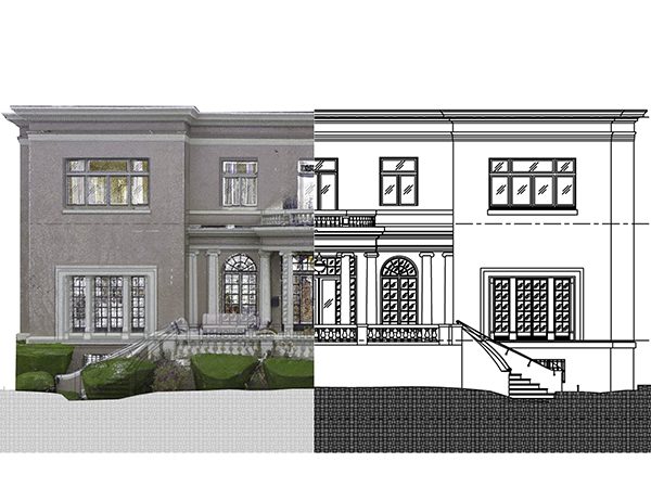
Precise As-Built CAD Drawings from Laser Scan Data
Renovation and construction projects require accurate existing conditions documentation before any design work begins. LiDAR Precise Plans deliver professional laser scan to CAD conversion services that capture buildings exactly as they exist today — eliminating the costly errors and change orders caused by inaccurate field measurements or outdated drawings.
Our process combines millimeter-accurate LiDAR scanning technology with experienced architectural drafting to produce construction-ready as-built CAD drawings. With 27 years of commercial architecture experience, we understand the documentation requirements of complex renovation projects across retail, hospitality, and commercial real estate.
What Is Included in Scan to CAD Services
Our scan to CAD services produce a complete set of 2D CAD drawings from point cloud data, organized to your CAD standards and delivered in AutoCAD DWG format. Standard documentation packages include:
- Floor Plans: Dimensioned floor plans showing walls, openings, columns, room dimensions, and architectural features — the most commonly requested deliverable in point cloud to CAD projects.
- Interior Elevations: Interior elevations documenting wall surfaces, finishes, millwork, and vertical building elements room by room.
- Exterior Elevations: Exterior building elevations documenting facades, fenestration, and vertical conditions.
- Building Sections: Cross-sections showing ceiling heights, structural systems, and vertical clearances.
- Reflected Ceiling Plans (RCPs): Ceiling layouts including lighting fixtures, HVAC grilles, sprinklers, ceiling grid systems, and ceiling height annotations.
- MEP Documentation: Visible mechanical, electrical, and plumbing systems including equipment locations and primary routing.
All CAD drawings from laser scan data are delivered in AutoCAD DWG format (compatible with AutoCAD 2013 through 2025), DXF exchange format, and PDF. Files are organized according to client CAD layer standards — including layer naming conventions, lineweights and drafting standards, title block formats, and annotation styles — for seamless integration with your existing project documentation.
Point Cloud to CAD Workflow
Our point cloud to CAD workflow follows a consistent four-step process that ensures accuracy, completeness, and on-time delivery:
Step 1 — Site Scanning
Professional-grade Leica, FARO, or Trimble laser scanners capture millions of precise measurements throughout the building. Each scan location documents architectural features, structural elements, and building systems with ±3mm accuracy. Typical scanning requires 6-8 hours for a 20,000 SF commercial space, with minimal disruption to ongoing operations.
Step 2 — Point Cloud Processing
Raw scan data is processed using Autodesk ReCap Pro and Leica Cyclone software. Multiple scans are registered together to create a unified, georeferenced point cloud. Registered point clouds are cleaned, organized, and prepared for CAD drafting. Processed point cloud data is available in industry-standard formats including RCP, E57, LAS, and PTS upon request.
Step 3 — 2D CAD Drawings from Point Cloud
Experienced CAD technicians extract construction documentation directly from registered point cloud data. Our team averages over 10 years of commercial architecture experience and produces drawings that reflect proper CAD layer standards, lineweights and drafting standards, and architectural conventions. This step produces your floor plans, elevations, sections, RCPs, and any additional 2D CAD drawings from point cloud data specified in your scope.
Step 4 — QA/QC Process and Delivery
Completed drawings undergo a formal QA/QC process — every dimension, annotation, layer assignment, and lineweight is verified against the original point cloud data. Files are checked for compliance with your specified CAD layer standards and drafting standards before final delivery as DWG as-built drawings, DXF, and PDF.
Scan to CAD Applications
Commercial Renovation
Renovation projects depend on accurate as-built CAD drawings to prevent design conflicts and construction delays. Our CAD drawings from laser scan data capture complete building information including architectural features, structural elements, and building systems that affect renovation design. Laser scan to CAD conversion eliminates the need for repeated site visits during the design phase.
Retail Store Development
National retail programs require consistent, accurate as-built documentation across multiple locations. LiDAR Precise Plans has provided laser scan to CAD services for Fortune 500 retail programs requiring CAD floor plans, elevations and sections, and reflected ceiling plans across high volumes of locations — including rollout programs for Nike, Apple, REI, Coca-Cola, and Urban Outfitters.
Facility Management
Property managers and facility teams use DWG as-built drawings for space planning, lease documentation, building system maintenance, and capital improvement planning. Point cloud to CAD conversion provides permanent, dimensionally accurate existing conditions documentation that supports informed facilities management over the life of the asset.
Historic Preservation
Historic buildings frequently lack accurate original construction documents. Laser scan to CAD conversion provides non-invasive documentation of existing conditions, architectural details, and structural systems essential for preservation planning and regulatory compliance — without any physical contact with historic surfaces.
Residential & Multi-Family
High-end residential renovations, estate remodels, and multi-family repositioning projects require the same dimensional precision as commercial work — often more so, given the tight tolerances of custom millwork, cabinetry, and finish systems. Laser scan to CAD conversion delivers accurate as-built floor plans, interior elevations, and building sections for single-family homes, luxury residences, condominiums, and apartment buildings where existing drawings are missing, inaccurate, or outdated.
Residential scan to CAD services are particularly valuable for: estate and historic home renovations where original drawings don’t exist; kitchen and bath remodels requiring precise as-built CAD drawings for custom cabinetry and millwork coordination; ADU and addition projects requiring accurate existing conditions before permit submittal; and multi-family apartment repositioning programs requiring consistent documentation across multiple units. All residential deliverables are produced as AutoCAD DWG files and PDFs, sized and organized to support permit applications, contractor bidding, and design development.
Healthcare & Hospital Facilities
Hospital renovations and healthcare facility projects involve some of the most complex existing conditions documentation in construction — layered MEP systems, infection control zones, regulatory compliance requirements, and occupied spaces that cannot be shut down for extended periods. Laser scan to CAD services provide healthcare facility teams with accurate as-built CAD drawings from a single low-disruption mobilization, minimizing patient and staff impact.
Healthcare scan to CAD deliverables commonly include: dimensioned floor plans documenting room configurations, corridor widths, and door clearances for FGI Guidelines compliance; reflected ceiling plans showing medical gas outlets, nurse call systems, lighting, and HVAC grilles; interior elevations for headwall units, casework, and equipment clearances; and building sections documenting ceiling plenum conditions and interstitial space for MEP routing. Our team has experience documenting occupied clinical environments and coordinating scan access around department operations, patient schedules, and infection control requirements.
Point cloud to CAD conversion is particularly effective for healthcare projects because it captures existing conditions completely in a single pass — reducing the number of site visits required in sterile or restricted clinical environments and providing a permanent digital record of pre-construction conditions for regulatory documentation.
How Accurate Is Scan to CAD?
LiDAR scanning achieves ±3mm measurement accuracy — two to four times more precise than traditional tape measure field measuring (±6mm to ±12mm). This precision directly reduces construction risk and eliminates the change orders caused by dimensional errors in hand-measured drawings.
Accuracy depends on scanning distance, surface reflectivity, and environmental conditions. Our QA/QC process includes dimensional verification of all completed CAD drawings against source point cloud data before delivery. Where project conditions require tighter tolerances, we document achievable accuracy in the project scope.
2D CAD vs. 3D BIM: Choosing the Right Deliverable
Both point cloud to CAD and point cloud to BIM workflows produce accurate documentation from the same laser scan data. The right choice depends on your downstream use:
| Consideration | 2D CAD (AutoCAD DWG) | 3D BIM (Revit) |
|---|---|---|
| Deliverable Format | Floor plans, elevations, sections, RCPs | Intelligent 3D model |
| Primary Software | AutoCAD 2025, DWG format | Revit, RVT format |
| Turnaround Time | 7–10 business days | 10–15 days |
| File Formats Delivered | DWG, DXF, PDF | RVT, IFC, PDF |
| CAD Layer Standards | Full compliance (AIA / client standards) | Revit families and parameters |
| Best Applications | Permit sets, renovation docs, construction drawings | MEP coordination, clash detection, FM |
| Typical Cost | Lower — ideal for most renovation projects | Higher — justified for complex coordination |
Traditional 2D CAD drawings from point cloud data serve the majority of commercial renovation and construction projects efficiently. 2D as-built CAD drawings integrate directly into AutoCAD-based design workflows and are the standard deliverable for permit sets, tenant improvement construction documents, and renovation planning. 3D BIM modeling from point clouds addresses specific MEP coordination, clash detection, and facility management requirements where an intelligent building model is required.
Technology and Equipment
Our production software represent the same platforms used by leading architecture, engineering, and construction firms:
- Scanning Hardware: Leica BLK series, FARO Focus, Trimble TX series laser scanners
- Processing Software: Autodesk ReCap Pro, Leica Cyclone, FARO Scene — producing registered point clouds in RCP, E57, LAS, and PTS formats
- CAD Production: AutoCAD 2025, AutoCAD Architecture — delivering DWG as-built drawings compatible with AutoCAD 2013 through 2025
Service Markets
LiDAR Precise Plans provides scan to CAD services across seven Southwest markets with local project management and rapid mobilization:
- Las Vegas, Nevada
- Phoenix, Arizona
- Los Angeles, California
- San Francisco, California
- Denver, Colorado
- Salt Lake City, Utah
- Austin, Texas
Services are available throughout the Southwest region and nationwide for established clients and larger project engagements.
Frequently Asked Questions About Scan to CAD Services
A: Scan to CAD services include site laser scanning, point cloud registration and processing, and production of 2D CAD drawings from point cloud data — delivered as AutoCAD DWG files, DXF, and PDF. Standard deliverables include dimensioned floor plans, interior and exterior elevations, building sections, and reflected ceiling plans. MEP documentation (visible systems), point cloud data files, and expanded deliverable sets are available as optional add-ons based on project scope.
A: Scan to CAD pricing depends on building square footage, documentation scope (number and type of drawings), and number of floors. Fixed-price project quotations are provided within 24 hours of inquiry with no obligation. Projects are priced as a single fixed fee covering site scanning, point cloud processing, CAD drafting, QA/QC review, and all deliverable files — there are no hourly billing surprises. Contact us at 888-543-2711 or info@lidarpreciseplans.com for a project quotation.
A: Standard scan to CAD turnaround is 7–10 business days from site scanning to final DWG as-built drawing delivery. Timeline varies based on building size, number of floors, documentation complexity, and deliverable scope. Site scanning typically requires 6-8 hours for a 20,000 SF commercial space. Expedited delivery is available for urgent project schedules.
A: Yes. All scan to CAD projects are delivered as AutoCAD DWG files compatible with AutoCAD 2013 through 2025. Standard file deliverables include DWG, DXF exchange format, and PDF documentation sets. Point cloud data is provided in RCP, E57, or LAS format upon request. Files are organized according to client-specified CAD layer standards including layer naming, lineweights and drafting standards, and title block formats.
A: Yes. CAD floor plans, elevations and sections are the core deliverable of our scan to CAD services. From a single laser scan mobilization, we produce dimensioned floor plans, interior elevations, exterior elevations, building sections, and reflected ceiling plans — a complete as-built documentation set. All drawings are produced as 2D CAD drawings from point cloud data and delivered in AutoCAD DWG format.
A: The point cloud to CAD workflow has four steps: (1) laser scanning captures millions of measurements throughout the building; (2) registered point clouds are created by aligning and processing all scan positions; (3) CAD technicians trace 2D drawings directly from the point cloud in AutoCAD; (4) a formal QA/QC process verifies all dimensions and CAD layer standards before delivery as DWG as-built drawings. Typical turnaround from site scanning to final delivery is 7–10 business days.
A: Traditional field measuring with tape measures and laser distance meters achieves ±6mm to ±12mm accuracy and typically requires multiple site visits. Laser scan to CAD conversion captures ±3mm accuracy in a single mobilization, documents hard-to-reach areas including ceiling conditions, wall cavities, and structural interstitial spaces, and creates a permanent digital record of existing conditions. The result is more accurate as-built CAD drawings delivered faster and with fewer return visits.
A: Yes. If you have point cloud files from a previous scan or another scanning provider, we can process and convert that data to AutoCAD CAD drawings. We accept all standard point cloud formats including E57, RCP, LAS, and PTS. This service is appropriate when scan data has been acquired but CAD drafting expertise is needed.
A: Scan to CAD services apply to commercial buildings, retail developments, hospitality properties, industrial facilities, and historic structures. The service is particularly valuable for complex renovations, buildings without accurate original drawings, multi-location retail rollout programs, and projects where dimensional accuracy directly impacts design decisions and construction budgets.
A: No. Laser scanning is non-invasive and requires no physical contact with building surfaces or systems. Most commercial spaces can be scanned during normal business hours with minor coordination to avoid active work areas. Scanning typically completes in 4–6 hours for a 20,000 SF space.
Request a Scan to CAD Project Quote
Project quotations are provided within 24 hours and include detailed scope, timeline, and fixed pricing. To request a quote, provide building square footage, number of floors, documentation requirements, and project schedule.
Phone: 888-543-2711
Email: info@lidarpreciseplans.com
Online: Request Project Quote via website contact form