Start your project with reliable, scan-accurate documentation you can trust.
STATS
Years in As-Built Documentation
U.S. Markets Served
±2mm
Verified Dimensional Accuracy
Buildings Documented
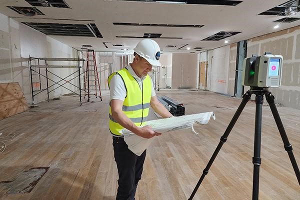
Accurate Existing Conditions Capture for Architecture, Engineering & Construction
Stop relying on outdated drawings and incomplete field notes. Our 3D laser scanning services capture real-world conditions fast and turn them into dependable registered point clouds and reality-capture datasets your team can confidently design, coordinate, and build from.
Quick Trust Points
- Professional field teams with documented QA/QC workflows
- Terrestrial laser scanning and reality capture best practices
- Registered point clouds aligned to your control strategy
- Clean handoff for Autodesk workflows and open formats
Trusted by teams across architecture, construction, retail, hospitality, and manufacturing


When 3D Laser Scanning Makes Sense
3D scanning is most valuable when accuracy, speed, and coordination matter more than “close enough” measurements.
Common triggers:
- Existing drawings don’t match reality
- Congested spaces (MEP rooms, plenums, risers, tight corridors)
- Complex geometry or multiple trades working in parallel
- Schedule pressure and limited site access
- High risk of rework, clashes, or prefab misfits
Who We Help
We work with teams that need reliable field data for design and construction decisions:
- Architects and design-build teams
- General contractors and specialty trades
- Engineers (structural, mechanical, electrical, plumbing)
- Owners and facility teams planning upgrades
- BIM/VDC teams responsible for coordination
- Teams capturing laser scan data for downstream as-built documentation
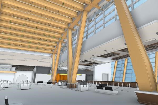
Our Reality Capture Approach
Not every project needs the same capture plan. We select the scanning strategy based on required accuracy, coverage, site conditions, and downstream use for CAD and BIM coordination , verification, and control requirements.
- Required accuracy and coverage
- Site conditions (line-of-sight, reflective surfaces, active operations)
- Downstream use (CAD, BIM, coordination, verification)
- Control requirements (targets, control points, or hybrid approach)
This keeps scan data usable—not just heavy.
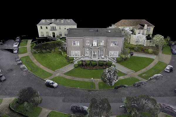
Registered Point Clouds & File Formats
Your team receives a clean, organized dataset that’s ready for design and coordination workflows.
Common formats:
- E57 (open exchange format)
- RCP/RCS (Autodesk ReCap workflows)
- LAS/LAZ (common LiDAR/point cloud standards)
If you need a specific naming structure, coordinate system, or packaging method, we align the output to your standards.
Accuracy, Control, and QA/QC
Accuracy depends on distance, control, occlusions, surface types, and site accessibility. We plan the capture method to match your requirements and apply checks before delivery.
Quality controls typically cover:
- Registration checks across scan stations
- Alignment verification tied to the agreed control strategy
- Consistency checks in critical areas (interfaces, tight MEP zones, tie-ins)
- Final review to reduce downstream surprises
If your project has tolerance requirements, we confirm them upfront and scope the capture plan accordingly.
Our 3D Laser Scanning Workflow
1) Scope & Capture Plan
We confirm the goal—documentation, coordination, verification, or modeling—then define coverage, access constraints, and the control approach.
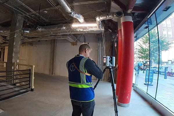
2) On-Site Scanning / Field Capture
We capture the site efficiently while ensuring coverage in critical areas such as interfaces, overhead conditions, equipment zones, and congested MEP.
3) Registration & Point Cloud Processing
We register scans into a unified point cloud, then clean and optimize the dataset for performance and usability.
4) Review & Handoff
We validate consistency and package the dataset in the agreed formats so your team can use it immediately.
Common Applications
Teams use scan data for:
- Existing conditions capture for renovation design
- Building documentation when drawings are missing or unreliable
- Construction coordination support and field verification
- Point cloud capture for BIM coordination and clash detection workflows
- Retrofit planning for mechanical upgrades and facility changes
Project Types We Scan
Commercial offices and tenant improvements
- Healthcare, education, retail, hospitality
- Industrial facilities and mechanical rooms
- Multi-story buildings, basements, and tight service corridors
- Exterior façades and site context (as required)
From Scan to As-Built Documentation
When the goal is as-built documentation, 3D laser scanning is the first step. We capture high-accuracy point cloud data and register it to serve as the foundation for downstream deliverables.
If your project requires finalized as-built drawings, CAD plans, or Revit models, our team provides complete documentation services built directly from verified scan data — accurate to ±2mm.
How Much Does 3D Laser Scanning Cost?
3D laser scanning pricing depends on site size, complexity, access conditions, and what you need back from us. Most commercial projects fall into one of these ranges:
| Project Size | Typical Scope | Starting Price |
|---|---|---|
| Small (under 5,000 sq ft) | Single-floor office, retail unit, condo | From $2,950 |
| Medium (5,000–20,000 sq ft) | Multi-floor commercial, TI, hospitality | From $5,000 |
| Large (20,000–50,000 sq ft) | Multi-story, complex MEP, industrial | From $7,500 |
| Enterprise (50,000+ sq ft) | Campus, portfolio, phased documentation | Custom quote |
What’s typically included:
- Field capture by a professional scan technician
- Registration of all scan stations into a unified point cloud
- QA/QC review before delivery
- Delivery in your required format (E57, RCP/RCS, or LAS/LAZ)
Factors that move the price up:
- Congested MEP areas or restricted access requiring additional setup time
- Tight accuracy tolerances requiring more scan overlap and control points
- Rush turnaround
- After-hours scanning in occupied buildings
For the fastest quote, send us: your location, approximate square footage, intended use, required formats, and deadline. We respond within one business day.
Timelines
Field capture for most commercial projects is completed in a single site visit. Buildings under 10,000 sq ft are typically captured in half a day. Larger or more complex facilities — multi-story buildings, congested MEP spaces, or phased access — may require multiple mobilizations.
Point cloud delivery follows field capture based on scope:
| Project Size | Standard Delivery | Rush Available |
|---|---|---|
| Under 10,000 sq ft | 10 business days | 24–48 hours |
| 10,000–30,000 sq ft | 10–12 business days | 48–72 hours |
| 30,000+ sq ft | 12+ business days | Contact us |
If you have a hard deadline — a construction window, a permit submission, or a contractor coordination meeting — tell us upfront. We plan the capture schedule around your constraints, not ours.
Occupied buildings and restricted access are routine for us. We coordinate scan windows around tenant hours, active construction shifts, and limited-access areas so your operations aren’t disrupted.
Where We Scan
LiDAR Precise Plans deploys field teams across seven U.S. markets. No subcontractors, no coordination delays — the same professional scan team and QA/QC standards on every project, in every city.
| Market | States Served |
|---|---|
| Las Vegas | Nevada |
| Phoenix | Arizona |
| Los Angeles | Southern California |
| San Francisco / Bay Area | Northern California |
| Denver | Colorado |
| Salt Lake City | Utah |
| Austin | Texas |
Working on a project outside these markets? We regularly mobilize for the right project. Contact us and we’ll let you know if we can support your location.
Testimonials
I am an architect in NYC, and recently worked with Shawn Wachter and the LiDAR team to scan, measure, and model in Scottsdale, Arizona. Shawn was great to work with - easy coordination, clear communication, and regular check ins made our work together extremely easy, and we now have an accurate BIM model 4 weeks later (even over the holidays)! We will absolutely reach out to LiDAR again in the future for as-built scanning and modeling needs. Thanks, team!
From NYC Architect
Frequently Asked Questions About 3D Laser Scanning
Cost depends on site size, complexity, access constraints, required accuracy, and turnaround time. Share your site details and required format for an accurate quote.
Accuracy varies based on control, range, line-of-sight, surfaces, and site conditions. We confirm target tolerances and apply QA/QC checks during registration and processing.
Typically: field capture, registration, point cloud processing, QA/QC review, and delivery in the agreed formats.
Most projects receive registered point clouds in E57, RCP/RCS, or LAS/LAZ, packaged to your workflow requirements.
Yes—registered point clouds are standard for most projects.
It depends on site size and access. Share your deadline and we’ll propose a schedule that fits your design or construction window.
We can support as-built documentation workflows depending on your requirements and standards. Share what you need and we’ll scope it correctly.
A registered point cloud is a 3D dataset in which all individual scans from multiple scan stations have been aligned into a single unified coordinate system. Registration combines overlapping scans using targets, natural features, or a hybrid control approach to produce one continuous, spatially accurate model of the site. Registered point clouds are the standard deliverable for design and BIM coordination workflows.
3D laser scanning uses pulsed laser light to capture millions of precise 3D measurements and works reliably indoors, in low light, and in congested mechanical spaces. Photogrammetry derives 3D geometry from overlapping photographs and is best suited for exteriors and aerial applications. For interior commercial and construction documentation, laser scanning is typically the more accurate and reliable method.
3D laser scanning produces point cloud files delivered in E57, RCP/RCS, or LAS/LAZ formats. E57 is an open exchange format compatible with most AEC software. RCP and RCS are Autodesk ReCap formats used directly in Revit and AutoCAD workflows. LAS and LAZ are standard LiDAR formats used in GIS, civil, and infrastructure applications. Custom formats and naming conventions are available on request.
3D laser scanning is used in construction for existing conditions documentation, as-built verification, MEP coordination, clash detection, retrofit planning, and BIM model creation. It captures spatial data faster and more accurately than manual measurement, reducing rework risk and providing a reliable field record for design and coordination decisions throughout the project lifecycle.
Yes, 3D laser scanning can be performed in occupied buildings and on active job sites. Scan equipment is non-invasive, uses eye-safe laser pulses, and requires no physical contact with surfaces. Field teams coordinate scan windows around tenant schedules, operational hours, and active construction shifts. Retail stores, occupied offices, and live hotel properties are routine scan environments.
LiDAR and 3D laser scanning refer to the same underlying technology — both use laser pulses to measure distance and capture three-dimensional spatial data. LiDAR is the broader term commonly used in aerial, autonomous vehicle, and geospatial applications. 3D laser scanning typically refers to terrestrial or close-range applications used in architecture, engineering, construction, and facility documentation.
Reality capture in construction is the process of collecting accurate, digital representations of existing physical conditions using scanning, imaging, or measurement technologies. 3D laser scanning is the primary reality capture method for interior construction documentation. The resulting point cloud or model gives design and construction teams a reliable record of what actually exists in the field, rather than relying on outdated drawings.
Request a Quote
Get a Quote for 3D Laser Scanning Services
Send the details below and we’ll respond with a clear scope.