Start your project with reliable, scan-accurate documentation you can trust.

About Our As-Built Drawing Services
Our as built drawings services help architects, contractors, engineers, property owners, and facility teams document real-world building conditions with accuracy. Using LiDAR laser scanning, field verification, and CAD drafting, we produce accurate as-built drawings for renovation, retrofit, tenant improvement, facility documentation, and design coordination.
We create 2D as-built drawings, as-built plans, and existing conditions drawings that show what is actually built on site rather than what was originally planned on paper. These deliverables give project teams a reliable base for planning, design development, permit preparation, and coordination before construction begins.
Depending on the project scope, our team can also support record drawings and construction as built drawings for buildings that need clear documentation of current conditions before renovation or future work moves forward.
What Are As-Built Drawings?
As-built drawings are drawings created to reflect the actual built condition of a space, structure, or property. They are used when original plans are outdated, incomplete, or no longer match what exists in the field. For architects, engineers, contractors, and owners, this documentation helps reduce guesswork and supports better planning.
In many projects, as-built drawings are used alongside record drawings, but the practical goal is the same: to provide dependable documentation of what is really there. When that information is captured with LiDAR scanning and checked through a structured drafting workflow, teams get a more accurate foundation for design, renovation, and decision-making.
Types of As-Built Drawings We Deliver
We provide as-built drawings services for a wide range of building types and project requirements. Based on the site, project goals, and required level of detail, we can deliver drawing sets that support both design and construction workflows.
Floor Plans
As-built floor plans document room layouts, wall locations, openings, circulation, and major built elements. These drawings are often used for renovation planning, lease planning, space verification, and existing conditions documentation.
Interior and Exterior Elevations
We prepare elevation drawings to show vertical building conditions, façade elements, wall features, openings, heights, and architectural details. These are useful when teams need reliable information before remodels, restoration work, façade updates, or envelope coordination.
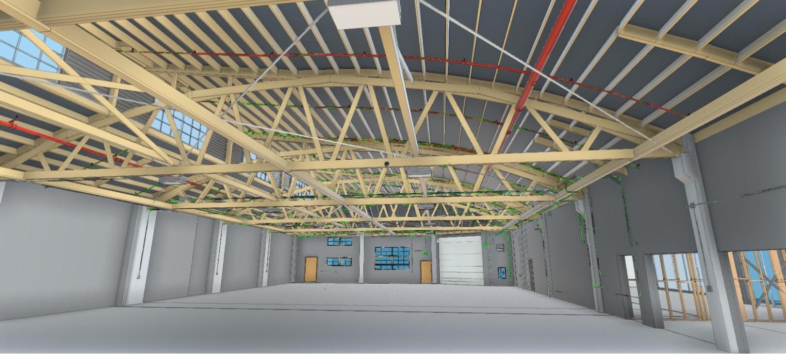
Building Sections
As-built sections help show how spaces, levels, and structural relationships come together. They are especially useful on multi-level buildings and renovation projects where ceiling heights, floor transitions, or hidden conditions may affect design decisions.
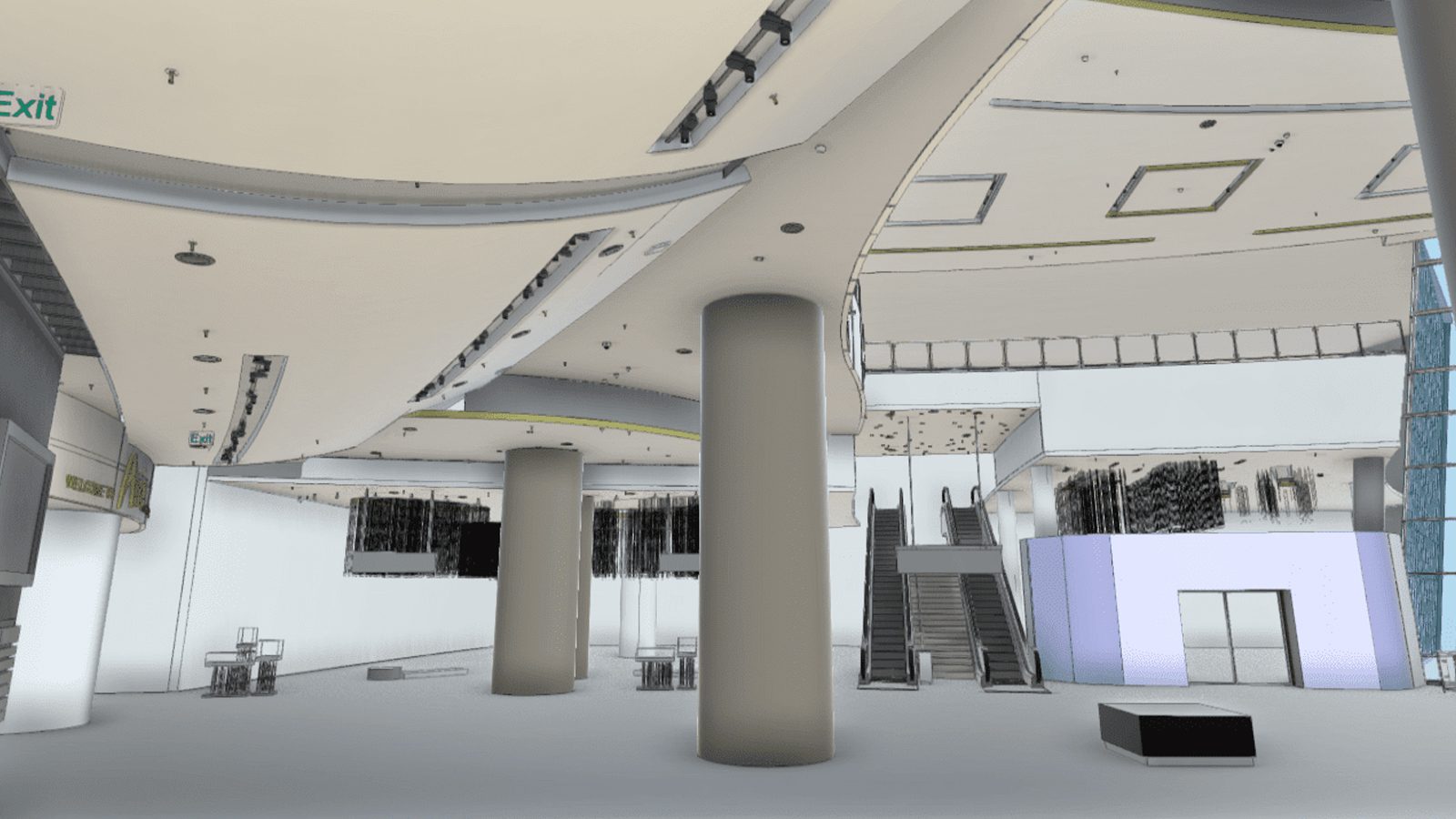
Reflected Ceiling Plans and Roof Plans
We can deliver reflected ceiling plans and roof plans when projects require above-ceiling coordination, ceiling feature documentation, lighting reference, or roof condition mapping. These drawings are often valuable for MEP coordination and renovation planning.
Site Plans and Existing Conditions Drawings
For projects that need more than interior documentation, we can create site plans and existing conditions drawings that show building footprint, exterior access points, surrounding features, and other site relationships that affect planning, design, and coordination. These deliverables help teams work from reliable existing conditions before renovation, layout changes, or further documentation begins.
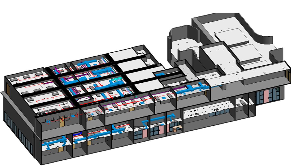
MEP and Specialty Documentation
Where needed, our workflow can also support construction as built drawings and field-based documentation for visible MEP systems, utility routing, and other built conditions that need to be captured before design or coordination begins.
2D As-Built Drawings and As-Built Plans from LiDAR Scanning
Our process combines LiDAR laser scanning, point cloud data, and manual quality checks to create reliable 2D as-built drawings and as-built plans. This approach reduces field guesswork and gives your team a stronger documentation base for design, planning, and renovation work.
Laser scanning for as-built drawings allows us to capture real site geometry quickly and with a high level of detail. From that data, we produce floor plans, elevations, sections, and existing conditions drawings in the formats your team uses most, including CAD and PDF deliverables, with Revit-based outputs available when needed.
This workflow is especially useful for buildings that are complex, occupied, older, or missing dependable documentation. Instead of relying only on hand measurements or outdated plans, teams receive as built drawings based on current field conditions and verified drafting workflows.
How LiDAR Laser Scanning Improves Accuracy
LiDAR scanning helps capture precise building geometry faster and more consistently than traditional manual methods alone. That matters on projects where dimensions, alignments, elevations, and built conditions directly affect design quality and coordination.
By working from point cloud data and field verification, our team can create as-built drawings that reflect actual site conditions with greater confidence. This improves the quality of the final drawing package and helps reduce rework caused by outdated or incomplete source information.
As-Built Drawings for Renovation, Retrofit, and Permit Documentation
Accurate as-built drawings are often the starting point for successful renovation and retrofit projects. Before a team can redesign a layout, coordinate trades, prepare permit documents, or evaluate building conditions, they need dependable information about what is already built.
Our as built drawings services are commonly used for tenant improvements, remodels, adaptive reuse projects, facility upgrades, code-related updates, and design coordination before construction begins. These drawing sets help reduce field surprises, support better planning, and improve communication between owners, architects, engineers, and contractors.
For many projects, as-built plans also support permit documentation by giving design teams a more accurate base to work from. Whether the project covers one part of a building or a full property, clear record drawings and existing conditions drawings can save time, reduce rework, and support better decisions throughout the project lifecycle.
Deliverables and File Formats
Deliverables can be tailored to the scope and documentation goals of the project. Depending on requirements, we can provide as-built drawings in PDF and CAD formats, along with point cloud data and Revit-ready outputs where needed.
This flexibility helps teams move from field capture to usable design and documentation files without relying on incomplete legacy plans.
Our QA/QC Process for Accurate As-Built Documentation
Our QA/QC process starts before drafting begins. Point cloud data is registered, reviewed, and checked against field notes, site photos, and visible building conditions so the project team is working from reliable source information.
After drafting, each drawing set goes through an internal review to verify dimensions, alignment, naming consistency, scope requirements, and requested deliverable formats. Final files are reviewed again before delivery so the as-built drawings, as-built plans, and existing conditions drawings reflect current field conditions as accurately as possible.
Key Components Documented:
- Architectural Elements: Wall locations, room dimensions, door/window placements, ceiling heights
- Structural Systems: Beam locations, column positions, foundation details, load-bearing walls
- MEP Systems: HVAC ductwork routes, plumbing line locations, electrical conduit paths, panel locations
- Site Conditions: Grading, utilities, parking layouts, landscaping features
- Material Specifications: Actual materials used, finishes installed, equipment specifications
What You Can Do With Accurate As-Built Drawings
Accurate as-built drawings give architects, engineers, contractors, and property owners a reliable foundation for decision-making. With field-verified existing conditions documentation, you can:
- Design renovations without costly field surprises
- Verify MEP routing before demolition begins
- Submit permit-ready documentation to building departments
- Support commercial due diligence and property valuation
- Plan phased tenant improvements with confidence
- Coordinate BIM modeling and clash detection workflows
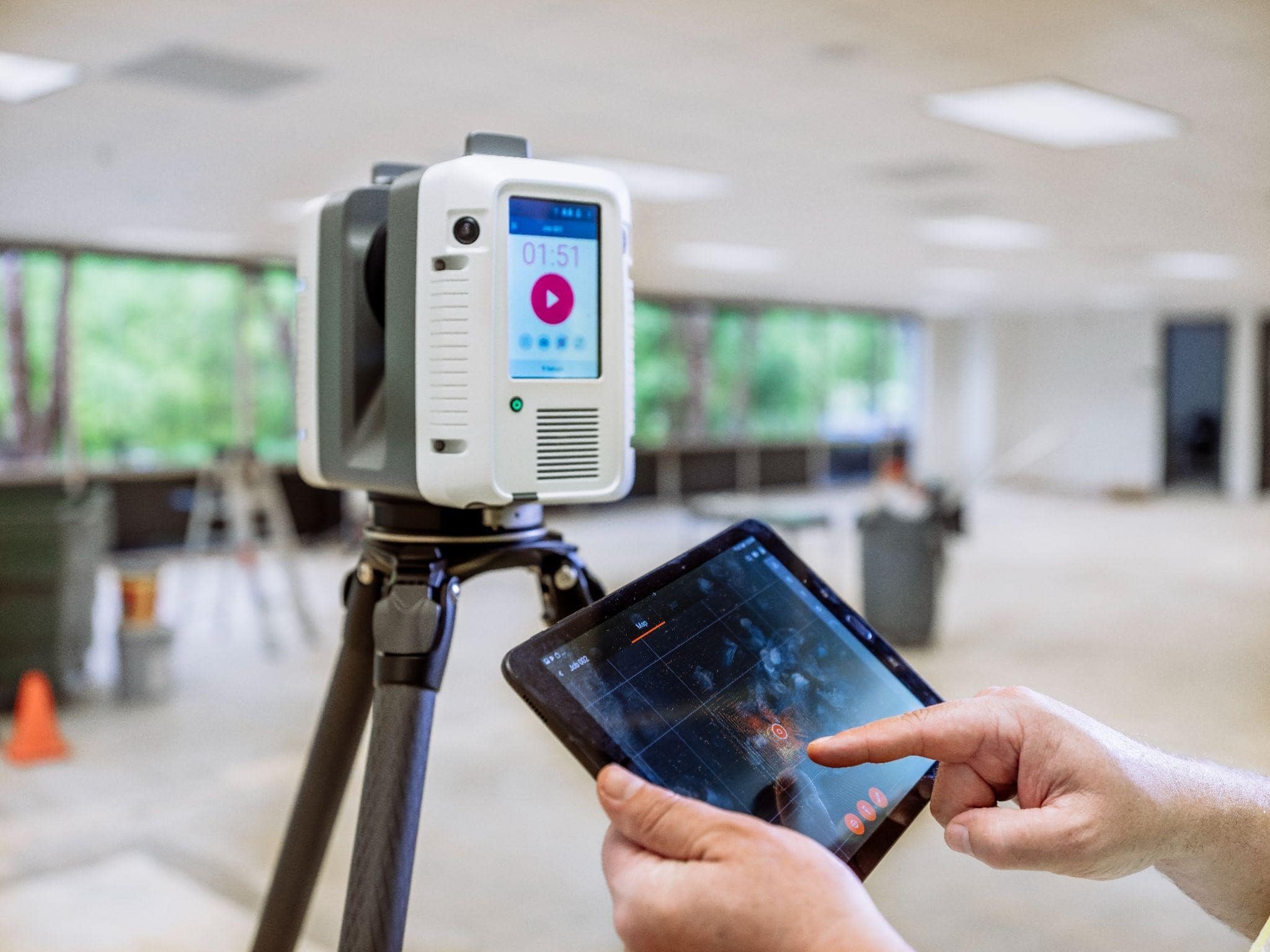
How 3D Laser Scanning Produces Accurate As-Built Drawings
Accurate as-built drawings begin with comprehensive field data capture. Using professional-grade LiDAR technology, our technicians document existing conditions by collecting millions of precise spatial measurements across the building interior and exterior.
This point cloud data is then registered, verified, and processed to create a complete digital record of the structure. From that dataset, our drafting and BIM team develops precise CAD drawings and Revit models that reflect true field conditions — not assumptions or selective measurements.
By building documentation directly from verified scan data, we reduce the risk of dimensional discrepancies, missing elements, and coordination conflicts that often occur with traditional manual measurement methods.
| Feature | Traditional Measurement | Laser-Scanned As-Built Drawings |
|---|---|---|
| Accuracy | Moderate | ±2mm |
| Time | Days–Weeks | Hours–Days |
| Detail | Limited | Full point cloud |
| Risk | Higher rework | Reduced field conflicts |
Comprehensive As-Built Drawing Services
3D Laser Scanning As-Built Services
Our state-of-the-art LiDAR scanning technology captures millions of data points per second, creating comprehensive point cloud models of your entire facility. This non-invasive process provides:
- Millimeter Accuracy: ±2-3mm precision across entire buildings
- Rapid Data Capture: Complete building scans in hours vs. days with traditional methods
- Safe Documentation: No disruption to operations or building occupants
- Comprehensive Coverage: Interior, exterior, rooftops, mechanical rooms, and hard-to-access areas
Scan-to-BIM Conversion Services
We transform point cloud data into intelligent 3D BIM models and 2D CAD drawings:
- Revit BIM Models: Fully parametric building models compatible with all major design software
- AutoCAD Drawings: Precise 2D floor plans, elevations, sections, and details
- LOD Customization: Level of Development from LOD 100 to LOD 400 based on project needs
- Multiple Format Delivery: DWG, RVT, IFC, PDF, and custom formats as required
Industry-Specific As-Built Services
- Commercial Buildings: Office buildings, retail centers, warehouses, and mixed-use developments
- Industrial Facilities: Manufacturing plants, processing facilities, power generation stations
- Healthcare Facilities: Hospitals, medical offices, surgical centers, diagnostic facilities
- Educational Institutions: Schools, universities, research facilities, dormitories
- Residential Properties: Custom homes, multi-family buildings, historic renovations
- Retail Spaces: Stores, restaurants, showrooms, and shopping centers requiring precise documentation for remodels, tenant improvements, or brand rollouts.
Our As-Built Drawing Process
Step 1: Project Consultation & Planning
We assess your specific requirements, timeline, and deliverable formats. Our team recommends the optimal documentation method based on project scope, budget, and accuracy requirements.
Step 2: Site Data Capture
- Laser Scanning Projects: Our certified technicians perform comprehensive 3D laser scans, typically completing most buildings in 4-8 hours.
- Traditional Surveys: Licensed surveyors conduct detailed field measurements with professional-grade equipment.
Step 3: Data Processing & Quality Control
- Point cloud registration and optimization
- Data verification against field notes
- Initial model development or CAD drafting
- Internal quality assurance review
Step 4: CAD/BIM Model Development
Our experienced drafters create accurate drawings following your specifications:
- Floor plans with precise dimensions
- Building elevations and sections
- Reflected ceiling plans
- MEP system layouts
- Detail drawings as required
Step 5: Review & Delivery
- Client review period with revision rounds
- Final quality control inspection
- Delivery in requested file formats
- Ongoing support for questions or modifications
Why Choose Lidar As-Built Drawings?
Unmatched Accuracy
Our 3D laser scanning technology delivers millimeter-level precision that manual measurements simply cannot match. This accuracy eliminates costly construction errors and design conflicts.
Faster Project Timelines
Traditional as-built documentation can take weeks. Our laser scanning captures complete buildings in hours — most projects delivered in 5–14 business days, 50-70% faster than conventional methods.
- Small projects (< 5,000 sq ft): 5–7 business days
- Medium projects (5,000–20,000 sq ft): 7–14 business days
- Large projects (> 20,000 sq ft): 14–21 business days
Cost-Effective Solutions
While laser scanning represents advanced technology, our efficient processes make professional as-built services affordable. We prevent expensive field rework by getting measurements right the first time.
Experienced Team
Our technicians and drafters average 10+ years of experience in as-built documentation. We understand building systems, construction terminology, and design requirements across all project types.
Technology Advantages
- Latest generation LiDAR scanners (Leica, FARO, Trimble)
- Advanced processing software (Autodesk ReCap, CloudCompare)
- Professional CAD/BIM platforms (AutoCAD, Revit)
- Secure cloud storage and file sharing
Common Applications for As-Built Drawings
Renovation & Remodeling Projects
Architects and contractors rely on accurate as-built drawings to design feasible renovations. Our documentation reveals:
- Actual wall locations and construction types
- Ceiling heights and structural constraints
- Existing MEP system locations
- Load-bearing elements and modifications
Tenant Improvement Projects
Commercial landlords and tenants need precise space documentation for:
- Space planning and layout design
- HVAC capacity and distribution planning
- Electrical and data infrastructure assessment
- ADA compliance verification
Facility Management & Operations
Building operators use as-built drawings for:
- Maintenance planning and scheduling
- System replacement and upgrades
- Emergency response planning
- Space utilization studies
- Energy efficiency improvements
Historic Building Preservation
Preservation architects require detailed documentation to:
- Record existing historic conditions
- Plan sensitive restoration work
- Comply with historic preservation standards
- Document changes over time
Structural Analysis & Engineering
Engineers need accurate as-built information to:
- Assess structural capacity for new loads
- Design seismic retrofits
- Evaluate foundation conditions
- Plan structural modifications
Real Estate Due Diligence
Property transactions depend on accurate documentation for:
- Investment analysis and valuation
- Lease negotiations, space verification, BOMA Standard Drawing
- Property condition assessments
- Portfolio management
Building Code Compliance
Permit applications and inspections require:
- Verification of existing conditions
- Documentation of unpermitted work
- Compliance analysis
- Certificate of occupancy requirements
Industries We Serve
Our as-built drawing services support professionals across multiple sectors:
- Architecture & Design Firms: Reliable existing conditions documentation for renovation designs
- General Contractors: Accurate field verification and construction closeout documentation
- MEP Contractors: Precise system routing and coordination for mechanical, electrical, and plumbing
- Structural Engineers: Detailed structural element documentation for analysis and modifications
- Facility Managers: Comprehensive building records for operations and maintenance
- Real Estate Developers: Due diligence documentation and property condition assessment
- Property Owners: Historical records for renovations, insurance, and asset management
- Government Agencies: Public building documentation and infrastructure records
Areas We Serve
We provide professional as-built drawing services throughout the Southwest and Western United States, including:
- Las Vegas and Southern Nevada
- Phoenix and the greater Arizona region
- Los Angeles and Southern California
- San Francisco Bay Area
- Denver and the Front Range
- Utah and the Intermountain West
- Central Texas
- For large commercial projects, we are available nationwide.
Primary Service Areas: Las Vegas, Los Angeles, San Francisco, Denver, Phoenix, Utah, and Central Texas.
Extended Service Areas: West Coast United States
National Projects: Available for significant projects anywhere in the United States
Advanced Technology for Superior Results
3D Laser Scanning Equipment
We utilize industry-leading laser scanning systems:
- Leica RTC360: Ultra-fast 3D laser scanner with integrated HDR imaging
- FARO Focus Series: High-accuracy phase-shift scanning for large facilities
Processing & Software Platforms
- Autodesk ReCap: Point cloud processing and registration
- AutoCAD & Revit: Professional CAD and BIM drafting
- CloudCompare: Advanced point cloud analysis
- Navisworks: 3D model coordination and clash detection
Traditional Survey Equipment
- Leica Total Stations for precise control surveys
- Bosch laser distance meters and layout tools
- Professional photography equipment for documentation
- iPad/tablet field documentation apps
Frequently Asked Questions About As-Built Drawings
A: As-built drawing costs vary based on building size, complexity, required accuracy, and deliverable format. Simple residential projects may start at $2,500-3,000, while complex commercial facilities can range from $5,000-50,000+. We provide detailed quotes after understanding your specific requirements. Contact us for a free project assessment.
A: Most projects are completed within 5-14 business days after site scanning. Simple buildings under 5,000 square feet typically take 5-7 days, while larger or more complex facilities may require 2-3 weeks. Rush services are available for time-sensitive projects.
A: Original construction drawings show the design intent before construction begins. As-built drawings document the actual built conditions, including all field changes, modifications, and deviations from the original plans. As-builts reflect reality; original drawings reflect intent.
A: Yes! We deliver as-built drawings in multiple formats including AutoCAD (.dwg), Revit (.rvt), PDF, and other formats as requested. We can also provide the raw point cloud data (.rcp, .e57) if needed for your own processing.
A: Laser scanning offers significant advantages: greater accuracy (±2mm vs ±1-2 inches), faster data capture (hours vs days), comprehensive documentation (millions of data points), and safer operations (minimal disruption). For complex buildings or detailed MEP documentation, laser scanning is strongly recommended.
A: Absolutely. Many of our clients have no existing documentation. We create comprehensive as-built drawings entirely from field measurements or laser scans, developing complete architectural, structural, and MEP drawings as needed.
A: Our as-built drawings are prepared to meet building department standards and can be stamped by licensed professionals when required. We’re familiar with municipal requirements across our service areas.
A: Yes. Our laser scanning is non-invasive and typically performed during normal business hours without disrupting building operations. We coordinate with facility managers to ensure minimal impact on occupants.
A: We create BIM models at various Levels of Development (LOD) from LOD 100 (conceptual) to LOD 400 (fabrication). Most as-built projects are delivered at LOD 200 to 300 (detailed design) with specific elements modeled at LOD 400 when required.
A: Our 3D laser scanning delivers ±2-3mm (±1/8″) accuracy across entire buildings. This precision far exceeds traditional measurement methods and meets or exceeds industry standards for construction documentation.
A: As-built drawings reflect actual field conditions based on site capture, measurement, and verification. Record drawings may be used more broadly to refer to documented project revisions, but in practice the two terms are often closely related. For renovation and existing conditions work, the goal is to produce clear and dependable documentation of what is truly built.
A: Yes. We use LiDAR laser scanning and point cloud data to create 2D as-built drawings such as floor plans, elevations, sections, and other existing conditions drawings based on real site conditions.
A: Yes. As-built plans are commonly used as the base documentation for renovation, retrofit, and tenant improvement projects so design teams can work from verified building conditions.
A: Deliverables can include floor plans, elevations, sections, reflected ceiling plans, roof plans, site plans, and other as-built drawings depending on the project scope and required level of detail.
Looking for professional as-built drawings for your home renovation?
We offer expert LiDAR 3D scanning services, accurate floor plans, and construction documentation that contractors trust. Get your free quote today and start your project with precision.