Start your project with reliable, scan-accurate documentation you can trust.

Trusted By


STATS
Years in Commercial Architecture
U.S. Markets Served
±1/2"
Verified Dimensional Accuracy
Buildings Documented
Hardware & Scanning Equipment
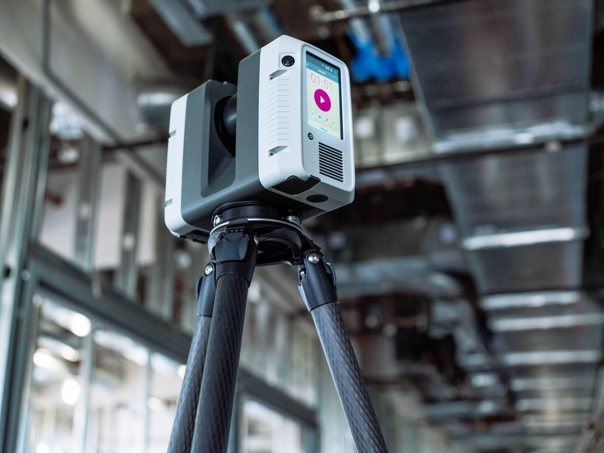
Professional-Grade LiDAR Scanners
We deploy the most advanced 3D laser scanning technology available, ensuring maximum accuracy, point density, and data quality for every project.
Leica RTC360 3D Laser Scanner
- Ultra-fast scanning capturing 2 million points per second
- Automatic in-field registration for faster project completion
- HDR imaging creates photo-realistic colorized point clouds
- Visual Inertial System (VIS) technology for enhanced accuracy
- Ideal for: Commercial buildings, hotels, retail, and complex interiors
Faro Focus Premium Scanner
- Long-range capability up to 350 meters
- Superior outdoor performance for façade documentation
- High-resolution photography integrated with scan data
- Proven reliability in demanding industrial environments
- Ideal for: Large facilities, exterior documentation, industrial plants
Matterport Pro3 Reality Capture
For projects requiring virtual tours, immersive property presentations, or marketing-focused documentation, we offer Matterport Pro3 scanning services.
- Matterport Pro3 Camera
- LiDAR-based 3D virtual tour creation
- Web-based interactive dollhouse views and floor plans
- 20-second scan capture per position
- Extended range up to 100 meters
- Operates in variable lighting conditions including direct sunlight
- Ideal for: Real estate marketing, facility walkthroughs, insurance documentation, stakeholder presentations
Technology Selection Guidance
We help clients select the appropriate capture method based on project requirements:
Choose Professional LiDAR (Leica/Faro) when:
- Architects require construction-grade as-built drawings
- Engineers need measurements for structural analysis or MEP coordination
- Contractors are bidding from your documentation
- BIM models must meet LOD 200+ standards
- Project requires ±1-3mm accuracy for renovation design
- Long-term facility documentation demands permanent data ownership
Choose Matterport when:
- Primary goal is virtual tour creation or property marketing
- Stakeholders need web-based immersive facility walkthroughs
- Insurance documentation requires visual spatial context
- Quick facility assessment guides preliminary planning
- Marketing teams need engaging digital presentations
- Budget prioritizes speed and accessibility over millimeter precision
Many projects benefit from both technologies—professional LiDAR for construction documentation combined with Matterport tours for stakeholder communication and marketing.
Accuracy Specifications & Tolerances Professional LiDAR Scanning Accuracy
Our equipment and processes deliver industry-leading dimensional accuracy:
Point Measurement Accuracy:
- Distance accuracy: ±1mm at 10 meters, ±2mm at 20 meters
- Angular accuracy: 19 arc seconds (0.005°)
- Overall model accuracy: ±2mm throughout entire scan dataset
- Meets or exceeds ASTM E2938 standards for 3D imaging
Registration Accuracy:
- Point cloud alignment: ±3mm between adjacent scans
- Global registration: ±5mm across entire building
- Verification through closed-loop traverse calculations
- Independent check measurements confirm stated tolerances
Deliverable Accuracy:
- CAD drawings: Dimensions accurate to ±1/4 inch (6mm) or better
- BIM models: Geometric accuracy suitable for construction coordination
- As-built documentation: Suitable for engineering calculations and permit submissions
- Quality guaranteed or we re-scan affected areas at no charge
Matterport Pro3 Accuracy
Matterport technology provides ±20mm accuracy at 10 meters, suitable for virtual tours, general facility documentation, and projects where visual context takes priority over construction-grade measurements.
Appropriate Applications:
- Property marketing and real estate listings
- Facility management walkthroughs
- Insurance claim documentation
- Preliminary space assessment
- Stakeholder presentations and virtual site visits
When Higher Precision Required:
For renovation design, construction coordination, or BIM workflows requiring tight tolerances, our professional LiDAR scanning provides the millimeter-level accuracy necessary for error-free project delivery.
Quality guaranteed or we re-scan affected areas at no charge
Our equipment and processes deliver industry-leading dimensional accuracy:
Point Cloud Processing, CAD Drafting & BIM Modeling Software
Our team is proficient in all major design, documentation, and BIM software platforms ensuring seamless integration with your existing workflows.
SOFTWARE CAPABILITIES & PLATFORMS
Raw LiDAR point cloud data requires specialized processing before it becomes usable CAD drawings or BIM models. Our team works in the same platforms used by architects and engineers — including Revit, AutoCAD, and Navisworks — and delivers files in the formats your team expects, from DWG and RVT to E57 point clouds. No conversion steps between our deliverables and your workflow.
Point Cloud Processing:
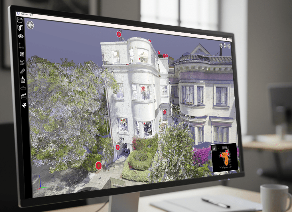
Registered LiDAR point cloud data is processed using specialized software to clean, align, and prepare scan data for modeling and drafting workflows. Each scan station is registered into a unified coordinate system, noise and artifacts are filtered out, and the resulting point cloud is validated for accuracy before any deliverable is produced.
This ensures the data your team receives is clean, georeferenced, and ready for use in CAD drawings, BIM models, or construction documentation — with no additional processing required on your end.
- Autodesk ReCap Pro: Point cloud registration and processing
- Leica Cyclone: Advanced point cloud manipulation and analysis
- Faro Scene: Scan processing and project management
- CloudCompare: Open-source analysis and comparison tools
- Matterport Cloud: Virtual tour processing and web hosting
2D CAD Documentation
Registered point cloud data is used to produce precise architectural drawings using professional drafting platforms.
- AutoCAD — Industry-standard CAD platform for architectural documentation
- AutoCAD Architecture — Architectural drafting and building documentation tools
- AutoCAD LT — Lightweight CAD platform for drafting and file compatibility
3D BIM Modeling
When BIM deliverables are required, point cloud data is converted into detailed building models used by architects, engineers, and contractors.
- Autodesk Revit — Building Information Modeling (BIM) platform
- Revit MEP — Mechanical, electrical, and plumbing system modeling
- Navisworks — Model coordination and clash detection
Visualization & Mesh Modeling
For certain projects, additional software is used for visualization, mesh modeling, or geometry reconstruction.
- SketchUp Pro — Conceptual modeling and visualization
- Archicad — BIM modeling platform used for architectural documentation and collaboration
Additional Export Formats Available Upon Request
- STEP (.STEP / .STP) — Neutral 3D format commonly used for engineering and fabrication workflows
Data Export Formats:
E57, RCP, LAS: Industry-standard point cloud formats
DWG, DXF: Universal CAD file compatibility
RVT: Revit BIM models
OBJ, FBX: 3D mesh exports
MatterPak: Matterport point cloud and texture bundles
Quality Assurance Process
Every project undergoes our rigorous three-tier quality control system ensuring deliverables meet the highest professional standards.
Technology Is Only as Good as the Team Using It
LiDAR Precise Plans combines professional-grade 3D laser scanning technology with 27 years of commercial architecture experience. Our projects are overseen by professionals with AIA Allied Membership across multiple U.S. markets, ensuring that scan data is translated into documentation architects and contractors can actually rely on.
Tier 1: Field Verification
- On-site scan coverage review before leaving property
- Real-time data quality checks during scanning
- Photographic documentation of site conditions
- Field measurements verify critical dimensions
- Technician sign-off confirms complete building capture
Tier 2: Data Processing QC
- Point cloud registration accuracy verification
- Check measurements confirm dimensional accuracy
- Data completeness review ensures no missing areas
- Alignment verification through independent measurements
- Processing supervisor approval before drafting begins
Tier 3: Final Deliverable Inspection
- Senior drafter reviews all drawings against point cloud
- Dimension checks verify accuracy of critical measurements
- Drawing coordination ensures consistency across sheets
- BIM model validation confirms standards compliance
- Project manager final approval before client delivery
Independent Verification:
- Random spot-checks by quality control team
- Peer review of complex or high-stakes projects
- Client feedback integrated into continuous improvement
- Annual accuracy audits validate equipment calibration
Technology-Specific QA:
For professional LiDAR projects: Registration accuracy verified to ±3mm through closed-loop traverses and independent check measurements.
For Matterport projects: Virtual tour completeness confirmed, navigation quality verified, and dollhouse model accuracy checked against project specifications.
Explore More About Our Process
At LiDAR As-Built Drawings, our commitment to precision goes beyond technology — it’s built into every step of our workflow. From high-speed laser scanning to detailed CAD and BIM deliverables, we ensure accuracy, efficiency, and seamless integration into your project.
Learn more about how our advanced tools and expertise come together across each stage of service:
- Our LiDAR Scanning Process – See how we capture millions of data points with millimeter precision.
- As-Built Drawing Services – Explore how we transform point clouds into accurate architectural documentation.
- BIM Modeling Services – Discover how our Revit-based 3D models support construction coordination.
- Matterport vs LiDAR Guide – Understand which reality capture technology your project needs
- Industries We Serve – From hotels to healthcare, see how LiDAR precision benefits every sector.
- Contact Us – Get a fast, no-obligation quote for your next scanning or documentation project.
Frequently Asked Questions: Our 3D Laser Scanning Equipment & Process
A: We deploy Leica RTC360 and FARO Focus Premium professional LiDAR scanners — the same instruments used by leading architecture, engineering, and construction firms worldwide. Scanner selection depends on project conditions and required range. The Leica RTC360 is our primary instrument for commercial interiors due to its speed and automatic registration, while the FARO Focus Premium is deployed on large facilities, exterior façades, and industrial environments requiring extended range up to 350 meters.
A: Our Leica and FARO scanners capture point measurement accuracy of ±1–2mm at typical working ranges. Delivered CAD drawings achieve dimensional accuracy of ±¼ inch (6mm) or better across the full building. All projects include closed-loop registration verification, and we guarantee accuracy or we re-scan affected areas at no charge.
A: We deliver in the formats your team already uses. Standard deliverables include DWG and DXF for CAD workflows, RVT for Revit BIM models, and E57, RCP, or LAS for raw point cloud files. If your project requires a specific format not listed here, contact us before project start and we will confirm compatibility.
A: Yes. Raw point cloud files are included with every project at no additional charge. You own your data permanently — there are no subscriptions, platform fees, or expiration dates on your files. This is a meaningful distinction from some platforms where your data is hosted on a third-party cloud and becomes inaccessible if a subscription lapses.
A: Our team works in Autodesk Revit, AutoCAD, Leica Cyclone, Autodesk ReCap Pro, FARO Scene, and Navisworks, among other platforms. This means your deliverables arrive in native formats that open directly in the tools your architects, engineers, and contractors are already using — no conversion steps required.
A: Yes. We produce Revit BIM models at LOD 200 through LOD 400 depending on project requirements. Our Revit MEP capability also supports full mechanical, electrical, and plumbing system documentation for renovation coordination and facilities management workflows.
A: Field scanning for a standard commercial space of 5,000–20,000 square feet is typically completed in one day or less. Larger facilities or multi-story buildings may require two to three days of field work. CAD drawing and BIM deliverable turnaround is typically five to ten business days from scan completion, with expedited options available.
A: Most 3D laser scanning projects cause minimal disruption. Our laser scanners operate silently and capture data without contact with building surfaces. In many cases, scanning can occur during normal business hours while occupants remain in place.
A: Yes. For projects where the primary goal is a virtual tour, immersive walkthrough, or stakeholder presentation rather than construction-grade documentation, we offer Matterport Pro3 scanning as a complementary service. Many projects benefit from both — professional LiDAR for the construction deliverables and Matterport for marketing or facility management visualization. For a full comparison of when each technology is appropriate, see our Scanner Technology Guide.