Start your project with reliable, scan-accurate documentation you can trust.

STATS
Years in Commercial Architecture
U.S. Markets Served
±1/2"
Verified Dimensional Accuracy
Buildings Documented
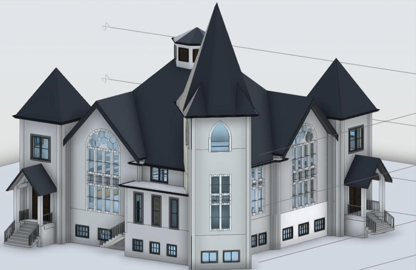
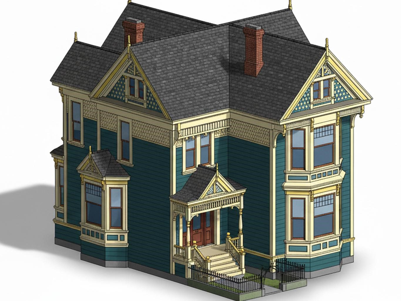
Historic Building Documentation Services for Preservation Architects
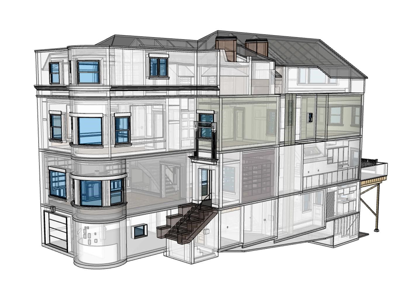
Our historic building documentation services provide preservation architects, consultants, and developers with precise existing-conditions drawings derived directly from 3D laser scan data. Unlike traditional field-measured surveys, our documentation reflects the true geometry of aging structures — including non-orthogonal walls, settled foundations, ornamental facades, and irregular ceiling profiles. Whether the project requires documentation for a historic tax credit application, restoration planning, or preservation board approval, our deliverables are structured to meet professional documentation standards.
What We Document on Historic Properties
Our 3D laser scanning process captures the full complexity of aging and ornate structures without physical contact. Deliverables include:
- Floor plans with dimensions — accurate to existing conditions, not design intent
- Reflected ceiling plans (RCPs) — capturing coffered ceilings, plaster ornamentation, and irregular roof structures
- Elevations and building sections — exterior facade documentation and interior cross-sections
- Ornamental and architectural detail capture — cornices, moldings, pilasters, column profiles
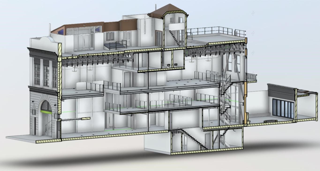
- Point cloud deliverables — raw scan data for your in-house team or BIM modeler
- Point cloud to CAD — clean, layered AutoCAD DWG files
- Point cloud to Revit — fully coordinated BIM models for heritage structures
- DWG and PDF as-built drawing sets — permit-ready and preservation board-ready
Accuracy & Tolerances — How Accurate Is Laser Scanning for Historic Buildings?
This is one of the most common questions preservation architects ask us. The Leica RTC360 scanner we use captures data at ±1.9mm accuracy at a range of 10 meters. In practical terms, this means our deliverables reflect true existing conditions — not estimated dimensions, not field-measured approximations.
For historic structures with settled foundations, bowed walls, or non-orthogonal geometry, this level of accuracy is essential. You cannot renovate or restore what you cannot accurately measure. Our scan-to-drawing workflow includes a rigorous QA/QC process: every scan is registered, reviewed for coverage gaps, and validated before drawings are produced.
Common Use Cases We Support
- Historic tax credit applications (federal and state programs)
- Restoration and renovation planning for landmarked buildings
- Documentation for permits and approvals from preservation boards
- Adaptive reuse of heritage buildings into hotels, retail, or residential
- Heritage site documentation for archives and cultural institutions
- Facade documentation for repair scopes and masonry restoration
- Scan to BIM for historic buildings entering LEED or energy audit programs
Deliverables, Formats & Turnaround Time
We understand that historic building documentation projects operate on tight deadlines — grant applications, board hearings, and contractor bid windows don’t wait. That’s why We prioritize fast turnaround on all historic documentation projects.
- Standard turnaround: 5–7 business days from scan date
- Rush turnaround: 48–72 hours (available on request)
- Deliverable formats: AutoCAD DWG, PDF drawing sets, Revit (.rvt), point cloud (.pts / .e57 / .rcp)
- Drawing content: Floor plans, elevations, sections, RCPs, details — scoped to your project needs
- Service area: Las Vegas, Phoenix, Los Angeles, San Francisco, Denver, Salt Lake City, Austin — and nationwide
Need a Full As-Built Drawing Package (Not Just Historic Documentation)?
Preservation work often starts with high-detail capture — but teams still need a clear scope, file standards, and reliable QA/QC to move into design, approvals, and construction. Our As-Built Drawings Services page shows how we structure projects, confirm tolerances, and deliver clean drawing sets from verified scan data.
Common outputs (scoped to board/permit needs):
- Floor plans, elevations, sections, and RCPs
- Detail capture for façade elements and irregular geometry
- DWG / PDF sets + optional Revit models
- Registered point clouds when your team needs raw data
Why LiDAR Is the Right Technology for Historic Preservation
Traditional field measuring on historic properties introduces risk — ladders against fragile plaster walls, tape measures that miss complex geometry, and field sketches that lose critical detail. LiDAR scanning eliminates all of that.
A single scan session with the Leica RTC360 captures millions of data points in minutes, creating a permanent, dimensionally accurate digital record of the building’s existing conditions. If design decisions change six months later, there’s no need to return to the site — the full point cloud is already on file.
Can you capture fine architectural details with laser scanning? Yes. The scanner resolves details as small as a few millimeters — meaning crown molding profiles, window surround geometry, and carved stone ornament are all captured with enough precision to produce fabrication-ready drawings.
Markets We Serve
We provide historic preservation as-built drawings and heritage site documentation across all seven of our service markets:
- Las Vegas, NV — historic downtown properties, mid-century modern documentation
- Phoenix, AZ — territorial and adobe heritage structures
- Los Angeles, CA — Craftsman, Art Deco, and Mission Revival architecture
- San Francisco, CA — Victorian, Edwardian, and early commercial structures
- Denver, CO — Victorian-era and early 20th century commercial buildings
- Salt Lake City, UT — pioneer-era and institutional heritage properties
- Austin / Central Texas — historic courthouses, churches, and civic landmarks
If you’re an architect, preservationist, developer, or property owner working on a historically significant structure, LiDAR Precise Plans is your documentation partner. We bring the accuracy, speed, and professional deliverables that preservation work demands — without disrupting fragile existing conditions.
Contact us today for a project quote. Tell us the building type, your market, and the deliverables you need — and we’ll send you a scope and timeline within 24 hours.
Frequently Asked Questions: Historic Preservation As-Built Drawings & LiDAR Scanning
A: Historic building documentation is the process of accurately recording the existing conditions of a historically significant structure through measured drawings, elevations, sections, and digital models. At LiDAR Precise Plans, we use 3D laser scanning technology to create dimensionally accurate as-built drawings and BIM models that reflect the true condition of the building — not assumed geometry.
A: Historic preservation as-built documentation typically includes floor plans with accurate dimensions, building elevations, cross-sections, reflected ceiling plans (RCPs), facade details, and ornamental architectural drawings. At LiDAR Precise Plans, we capture all of this from a single 3D laser scanning session using the Leica RTC360, producing deliverables in AutoCAD DWG, PDF, and Revit BIM formats. The scope is tailored to your project — from a single-floor plan set for a permit submittal to a full building documentation package for a historic tax credit application.
A: The Leica RTC360 scanner we use achieves ±1.9mm accuracy at 10 meters range. In practical terms, this means every wall, column, arch, and ornamental feature in your building is captured with sub-quarter-inch precision. This level of accuracy is especially critical for historic structures where settling, bowing, and irregular geometry are common — conditions that traditional tape-measure surveys can't reliably document. Our drawings reflect true existing conditions, not design intent.
A: Historic preservation as-built drawings are priced based on building size (square footage), scope of deliverables (floor plans only vs. full building documentation), level of detail required, and project location. Most projects fall in the range of a few thousand dollars for a single-floor scan-to-CAD deliverable, scaling up for multi-story or highly detailed landmark structures. Contact LiDAR Precise Plans at 888-543-2711 or through our quote form for a project-specific estimate — we respond within 24 hours.
A: Our standard turnaround from scan date to final deliverables is 5–7 business days. Rush turnaround (48–72 hours) is available for time-sensitive projects such as grant application deadlines, permit submissions, or contractor bid windows. Turnaround time may vary for very large or complex structures. We communicate a firm delivery date at project kickoff.
A: Yes. LiDAR Precise Plans delivers historic preservation documentation in AutoCAD DWG, PDF drawing sets, and Revit BIM models (.rvt). We also provide raw point cloud files in .pts, .e57, and .rcp formats if your team has in-house CAD or BIM capabilities. All deliverables are organized by drawing type (floor plans, elevations, sections, details) and labeled to your project naming conventions.
A: Yes. Exterior facade documentation — including elevation drawings at all four faces — is one of the most common deliverables requested for historic preservation work. We also produce building sections, interior elevations, and construction detail drawings for ornamental features such as cornices, window surrounds, column capitals, and carved masonry. These are essential for restoration scopes, preservation board submissions, and historic tax credit applications.
A: Yes. The Leica RTC360 captures point data at millimeter-level resolution, meaning fine architectural details — molding profiles, carved stone ornamentation, plaster ceiling relief, wrought iron work — are all documented with measurable accuracy. For fabrication-level detail drawings, our technicians extract profiles and dimensions directly from the scan data, eliminating guesswork from restoration fabrication scopes.
A: Yes. Our entire workflow is scan-to-drawings. We capture the existing conditions of your historic structure with our 3D laser scanner, register the point cloud, and produce clean, layered CAD or BIM drawings from that data. This workflow works for any building type — churches, courthouses, schools, hotels, civic landmarks, warehouses, and residential historic properties. We do not use manual field measuring.
A: Yes. 3D laser scanning is entirely non-invasive and non-contact. The scanner emits laser pulses that bounce off surfaces to measure distance — no physical contact with walls, ceilings, or ornamental features is required. This makes it the preferred documentation method for fragile plaster surfaces, historic masonry, and delicate ornamentation where traditional measuring methods risk damage.
A: Yes. Historic tax credit applications (both the federal Historic Tax Credit program administered through the National Park Service and various state programs) require accurate existing conditions documentation. Our as-built drawings — floor plans, elevations, sections, and facade details — meet the documentation standards required for Part 1 and Part 2 applications. We recommend confirming specific documentation requirements with your State Historic Preservation Office (SHPO) prior to scanning.
A: Yes. We deliver Revit BIM models for historic structures as part of our Scan to BIM service. These models include architectural geometry, room boundaries, wall profiles, ceiling heights, and structural elements as captured from the point cloud. BIM models for historic buildings are used in adaptive reuse projects, energy modeling, phased renovation planning, and LEED certification workflows.
A: Our QA/QC process includes: (1) full scan registration review — ensuring all scan positions are correctly aligned and coverage is complete; (2) dimensional accuracy spot-checks against known reference points; (3) drawing review against point cloud to confirm all features are captured and dimensioned; and (4) a final deliverable review by a senior team member before files are issued to the client. For historic structures, we pay particular attention to non-orthogonal conditions and irregular geometry that require manual verification.
A: We document all types of historically significant structures, including: landmark churches and religious buildings, historic courthouses and civic buildings, Victorian and Craftsman residential properties, Art Deco and Mission Revival commercial buildings, historic hotels and hospitality properties, industrial heritage structures (mills, warehouses, firehouses), and buildings listed on or being nominated to the National Register of Historic Places. We work across Las Vegas, Phoenix, Los Angeles, San Francisco, Denver, Salt Lake City, and Central Texas.
A: Yes. Accurate as-built documentation is the foundation of every successful historic renovation. Before a contractor can scope window replacements, floor repairs, plaster restoration, or structural interventions, they need drawings that reflect true existing conditions. Our scan-to-CAD deliverables give your design and construction teams the accurate base drawings needed to plan, bid, and execute restoration work without surprises.
A: LiDAR Precise Plans provides historic preservation as-built drawings in Las Vegas, Phoenix, Los Angeles, San Francisco, Denver, Salt Lake City, and Austin / Central Texas. We also accept projects nationally — contact us to discuss your location and we will confirm service availability and travel scope.

We know the potential pitfalls with 3D Laser Scanners. This free guide will make sure you don’t run into them on your projects.