You’re three weeks into pre-design for a tenant improvement on a 1920s brick commercial building in the Mission District. The original construction documents are gone. San Francisco’s Planning Department has flagged the property as a Category B historic resource under CEQA, and your SHPO coordinator just confirmed that any scope touching the facade or structural system requires measured documentation before a permit moves forward.
A tape measure and a clipboard are not going to get you there.
This is the operational reality of historic work in San Francisco. The city’s built environment sits under overlapping federal, state, and local preservation frameworks that impose real documentation burdens before a single wall is touched. 3D laser scanning for historic buildings in San Francisco resolves that burden directly: it captures existing conditions at plus or minus 2mm accuracy, produces deliverables that satisfy HABS, HAER, Section 106, and CEQA requirements, and eliminates the fieldwork gaps that derail permit submittals.
Why LiDAR Matters for Historic SF Projects
3D laser scanning for historic buildings in San Francisco captures full-facility existing conditions at plus or minus 2 mm/plus or minus 1/8 inch accuracy, producing point clouds, measured drawings, and Revit models that satisfy SHPO review, HABS documentation standards, Section 106 compliance, and San Francisco’s CEQA historic resource requirements.
Scan data is collected in a single mobilization, processed within 5 to 14 business days, and delivered as AutoCAD (.dwg), Revit (.rvt), or PDF. See our 3D laser scanning services and as-built drawings pages for scope and turnaround details.
Why San Francisco Historic Projects Require Accurate Documentation
San Francisco operates under a layered preservation system that goes well beyond the SHPO review process most AEC professionals encounter in other states. The layer that applies to your project determines exactly what you must produce before any scope is approved.
Federal Section 106 Requirements
Projects using federal funding, permits, or licenses on properties listed in, or eligible for, the National Register of Historic Places must comply with Section 106 of the National Historic Preservation Act.
Section 106 review requires consultation with the State Historic Preservation Officer and, for significant properties, production of measured record drawings meeting HABS standards before demolition or alteration proceeds.
CEQA Historic Resource Requirements
California’s CEQA (California Environmental Quality Act) requires lead agencies to evaluate impacts on historic resources for virtually any discretionary project. San Francisco’s Planning Department applies a local tiered classification:
Category A: Individually significant or eligible for the California Register
Category B: Contributing to a recognized historic district
Both categories trigger documentation requirements under CEQA Guidelines Section 15064.5. A large share of San Francisco’s pre-1940 building stock falls into one of them.
Article 10 and Article 11 Review
At the local level, San Francisco’s Article 10 and Article 11 of the Planning Code govern landmarks and buildings in the city’s 11 designated historic districts: the Market Street Commercial District, the South of Market Industrial Heritage District, the Western Addition, and others.
Work on Article 10 and Article 11 properties requires Historic Preservation Commission review and, for significant alterations, documentation of existing conditions before approval is granted.
What HABS and SHPO Documentation Actually Requires
HABS documentation is the federal benchmark for historic building record-keeping. Archived permanently in the Library of Congress, HABS drawings must meet specific standards for accuracy, completeness, and archival quality. California’s OHP applies these standards as the baseline for Section 106 documentation and CEQA mitigation measures.
HABS Documentation Levels
The NPS assigns three levels of HABS documentation based on a structure’s significance and the nature of proposed work:
- HABS Level I: Full documentation including large-format photography, measured drawings (plans, elevations, sections, details), and written historical data. Required for nationally significant structures or total demolition.
- HABS Level II: Measured drawings and photography without a full written history. Required for significant alterations to contributing structures. The operative standard for most active TI and rehabilitation projects in San Francisco.
- HABS Level III: Photography and written data without full measured drawings. Required for minor work on less significant resources.
HABS does not specify the field method used to produce drawings. Point cloud-derived CAD drawings meet the accuracy standard and have been accepted by both NPS and California OHP for HABS submissions. The critical requirement is dimensional accuracy, not how it was achieved.
What SHPO Reviewers Evaluate
California’s OHP reviewers evaluate Section 106 packages against three criteria:
- Accuracy of measured drawings
- Completeness of photographic coverage
- Adequacy of written historical context
For measured drawings specifically, OHP guidance references the HABS standard of plus or minus 1/8 inch dimensional accuracy as the threshold for acceptable submittals. That tolerance maps directly to modern terrestrial LiDAR output. Our equipment captures at plus or minus 2 mm/plus or minus 1/8 inch verified dimensional accuracy, satisfying OHP’s measurement standard at every scale from site plans to decorative detail drawings.
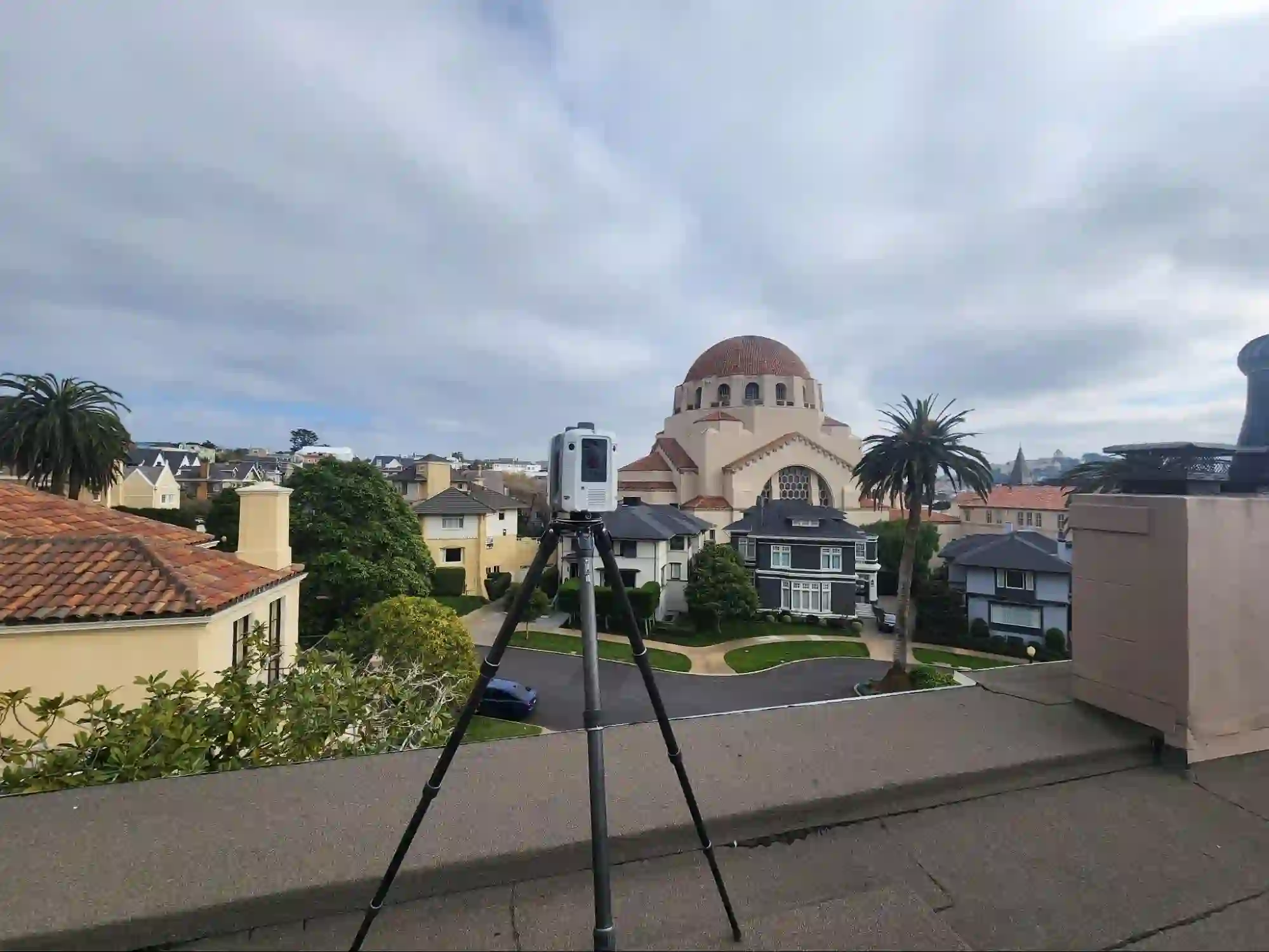
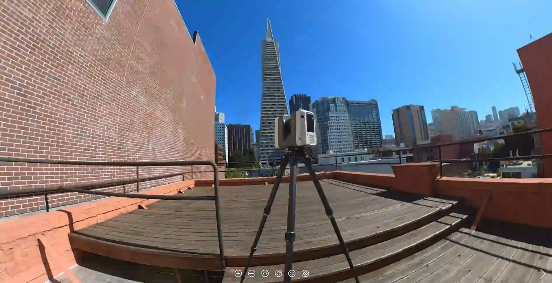
How LiDAR Scanning Works on Historic Buildings
Scanning a historic building is not the same as scanning a modern commercial shell. Irregular geometry, high-relief surfaces, and historic fabric that cannot be moved require careful station sequencing and a registration strategy built for complexity.
Pre-Scan Assessment
Before mobilization, available record documents are reviewed, areas of restricted access are identified, and the scope is confirmed with the architect or preservation consultant. For multi-story buildings, vertical control points are established in advance.
Exterior Capture
Facades, cornices, window surrounds, and decorative masonry require close-range scanning to resolve fine geometry at HABS detail drawing scale. Multi-story facades inaccessible at grade use extended-range configurations or phased setups from upper-floor windows.
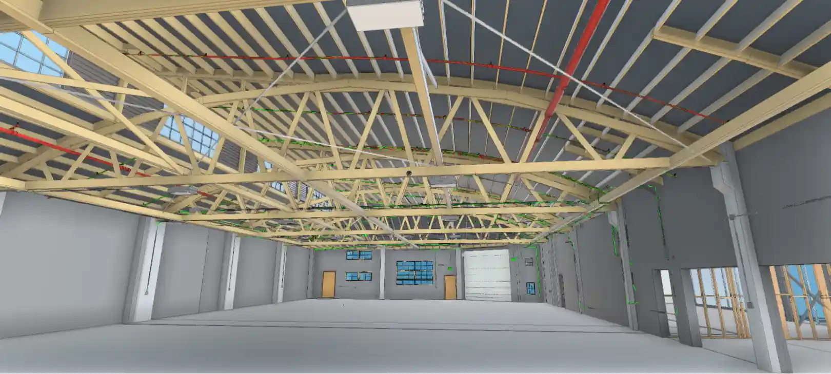
MEP and Structural Documentation
For tenant improvement scopes, exposed mechanical, electrical, and plumbing systems within the building envelope are captured simultaneously during the same mobilization. This eliminates the need for a separate MEP documentation visit.
For a typical 5,000 to 15,000-square-foot historic commercial building in San Francisco, field time runs four to eight hours. Deliverables return within 5 to 14 business days. Quotes are returned within 24 hours of scope submission.
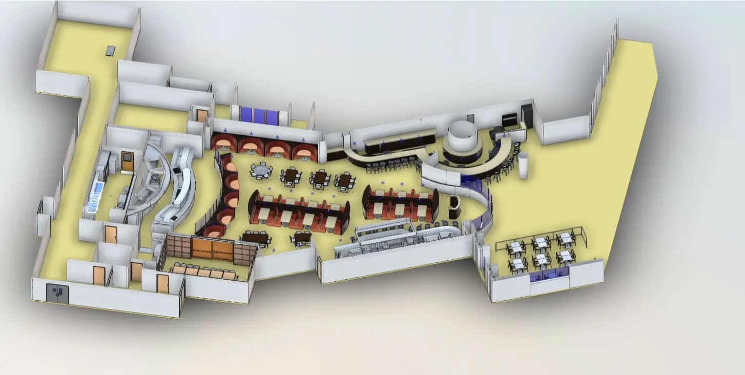
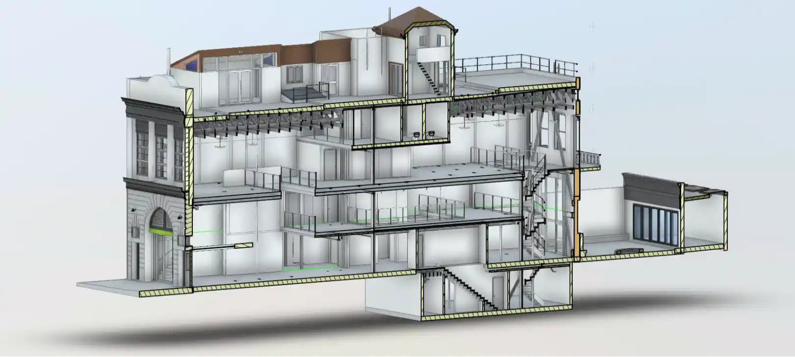
Scan-to-BIM vs. Scan-to-CAD for Historic Preservation
Not every historic project requires a Revit model. Matching the deliverable format to the project phase and regulatory requirements saves both time and budget. Here is how each scenario maps:
| Project Scenario | Recommended Deliverable | Why |
| HABS Level II documentation for SHPO submittal | Scan-to-CAD (.dwg / PDF) | HABS measured drawings are 2D deliverables. CAD produces them directly at the required scales and tolerances. |
| Tenant improvement design in a historic building | Scan-to-BIM (Revit) | Design teams work in Revit. A BIM model of existing conditions eliminates re-modeling effort and supports MEP clash detection. |
| Structural assessment or seismic evaluation | Point cloud + Scan-to-CAD | Structural engineers work from 2D drawings. Point cloud access lets engineers query geometry directly. |
| Historic district design review submission | Scan-to-CAD (.dwg / PDF) | Planning Commission submissions require 2D elevation and plan drawings. CAD meets this directly. |
| Full rehabilitation or adaptive reuse | Scan-to-BIM (Revit) + point cloud | Full rehabilitation needs a coordinated BIM model for all disciplines. The point cloud is retained for reference during construction administration. |
For projects requiring both HABS compliance documentation and a design-phase BIM model, both deliverables are produced from a single field mobilization. See our Scan-to-BIM services and Scan-to-CAD services pages for format-specific detail.
The Real Cost of Bad Historic Documentation
Consider a tenant improvement in a registered historic commercial building in the Financial District. The design team works from record drawings that are 40 years out of date. Drawings are submitted to Planning. SHPO review identifies dimensional discrepancies between the submitted plans and the actual building.
Revision and resubmittal add six to eight weeks to the review cycle. The contractor’s mobilization costs, stored materials, and subcontractor scheduling generate $40,000 to $80,000 in delay-related costs before a single permit is issued.
That scenario is not rare on San Francisco historic projects. It is the default outcome when existing conditions documentation is built on incomplete field measurements.
According to data from the Dodge Construction Network, rework caused by inaccurate field documentation accounts for approximately 9% of total construction costs on renovation and adaptive reuse projects. On a $2 million historic rehabilitation in San Francisco, that is $180,000 in avoidable rework.
The cost of a comprehensive LiDAR scan and as-built drawing package for a building of that size is typically $3,500 to $8,500, a fraction of a single rework event. See our resource on the cost of bad building documentation for additional project framing.
Beyond direct cost, inaccurate documentation on a historic resource carries regulatory risk. SHPO reviewers who identify deficiencies can require additional field investigation, additional mitigation documentation, or stop-work orders if work has already begun. For projects with a federal nexus under Section 106, incomplete documentation can trigger Advisory Council on Historic Preservation involvement, adding months to the review timeline.
San Francisco-Specific Challenges
San Francisco’s historic building stock presents documentation conditions that do not exist in most other markets. Three situations recur on nearly every engagement.
Unreinforced Masonry Buildings
San Francisco has approximately 4,900 unreinforced masonry (URM) buildings, the highest concentration of any major U.S. city. Many are listed as historic resources. URM buildings that have been seismically retrofitted often contain anchor bolts, steel moment frames, and shotcrete walls, not reflected in any existing documentation.
Scanning captures these as-modified conditions accurately, providing the baseline structural engineers need for further seismic evaluation or upgrade design.
Post-1906 Reconstruction Conditions
A significant portion of San Francisco’s pre-1910 building stock was rebuilt after the 1906 earthquake and fire. These buildings frequently incorporate non-original materials, altered floor plans, and structural modifications that make original record documents unreliable, even when they exist.
Point cloud data verifies actual conditions without relying on records whose accuracy cannot be confirmed.
Hillside and Split-Level Geometry
San Francisco’s topography produces unusually complex building geometry: split-level interiors, stepped foundations, and facades that change floor count at mid-block. Conventional fieldwork on these buildings is slow, error-prone, and expensive.
A single scanning mobilization captures the full three-dimensional geometry of a hillside building in a fraction of the time required for manual measurement. The resulting point cloud supports accurate drawings at every level without interpolation.
How LiDAR Precise Plans Handles Historic SF Projects
At LiDAR Precise Plans, we have documented more than 4,200 buildings across the western United States, including a substantial number of historic commercial, residential, and industrial structures in the San Francisco Bay Area.
When a project involves SHPO review, HABS documentation, CEQA compliance, or Planning Commission submittal, we configure the scan scope, deliverable format, and accuracy verification to the specific regulatory requirement, not just the general project type.
Our equipment captures at plus or minus 2 mm/plus or minus 1/8 inch, with verified dimensional accuracy. Deliverables return in AutoCAD (.dwg), Revit (.rvt), or PDF within 5 to 14 business days. Quotes come back within 24 hours.
If your project is in a San Francisco historic district or involves SHPO coordination, note that at the quote stage, we will flag any deliverable format or accuracy documentation requirements specific to your review track. See our full 3D laser scanning services page for scope details.
Why Historic Buildings in San Francisco Require 3D Laser Scanning
3D laser scanning for historic buildings in San Francisco is not a niche specialty. It is the production method that satisfies the accuracy, completeness, and turnaround requirements that San Francisco’s regulatory environment actually imposes.
The city’s combination of dense historic building stock, overlapping preservation frameworks, complex building geometry, and active construction activity makes high-accuracy existing conditions documentation foundational, not optional.
Projects that invest in LiDAR documentation at the outset move through SHPO review, Planning Commission approval, and permit issuance with fewer revision cycles and fewer field conflicts during construction. That return is measurable against any project budget.
Need 3D Laser Scanning for a Historic Building in San Francisco?
LiDAR Precise Plans documents historic preservation as-built drawings to HABS, SHPO, and CEQA standards with verified plus or minus 2mm accuracy. Get a scope-specific quote within 24 hours.
Call 888-543-2711 or submit your project now!